File:Custer Battlefield in the Crow Reservation, MT, established May 7, 1868.png

Size of this preview: 800 × 439 pixels. Other resolutions: 320 × 176 pixels | 640 × 351 pixels | 1,024 × 562 pixels | 1,280 × 702 pixels | 2,560 × 1,405 pixels | 3,864 × 2,120 pixels.
Original file (3,864 × 2,120 pixels, file size: 15.47 MB, MIME type: image/png)
Captions
Captions
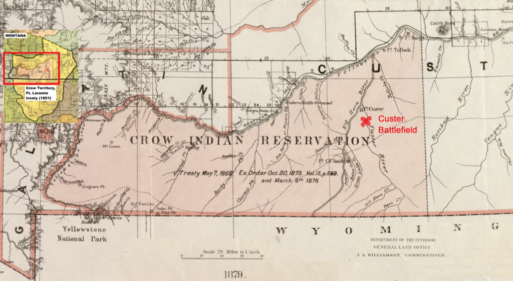
A map showing the Custer Battlefield at the Little Bighorn River (1876) in the Crow Reservation, Montana, established on May 7, 1868
Summary
edit
| Description |
Dansk: Kortet viser Custer Battlefield ved Little Bighorn River (1876) i crow reservatet i Montana. Reservatet blev oprettet den 7. maj 1868 i hjertet af crowernes territorium som fastlagt i Fort Laramie traktaten (1851) (se det lille indsatte kort) og også anerkendt som sådan af lakotaerne.
English: The map shows the Custer Battlefield at the Little Bighorn River (1876) in the Crow Reservation, Montana, established on May 7, 1868. The reservation was located in the heart of the Crow territory as acknowledged by the Lakotas with the signing of the Fort Laramie treaty (1851) – see the little map in the upper, left corner. |
| Date | |
| Source | www.loc.gov/resource/g4250.cws00190 (Detail of a 1879 map of Montana Territory and adapted to show the Custer Battlefield at the Little Bighorn River in the Crow Reservation) |
| Author | Roeser, Charles |
Licensing
edit
This work is in the public domain in the United States because it was published (or registered with the U.S. Copyright Office) before January 1, 1929.
Public domain works must be out of copyright in both the United States and in the source country of the work in order to be hosted on the Commons. If the work is not a U.S. work, the file must have an additional copyright tag indicating the copyright status in the source country.
Note: This tag should not be used for sound recordings. |

|
This is a file uploaded through the Danish Wikipedia, which has not been reviewed on Commons:
|
File history
Click on a date/time to view the file as it appeared at that time.
| Date/Time | Thumbnail | Dimensions | User | Comment | |
|---|---|---|---|---|---|
| current | 08:58, 18 September 2022 | | 3,864 × 2,120 (15.47 MB) | Indianertosset (talk | contribs) | Uploaded a work by Roeser, Charles from www.loc.gov/resource/g4250.cws00190 (Detail of a 1879 map of Montana Territory and adapted to show the Custer Battlefield at the Little Bighorn River in the Crow Reservation) with UploadWizard |
You cannot overwrite this file.
File usage on Commons
There are no pages that use this file.
File usage on other wikis
The following other wikis use this file:
- Usage on da.wikipedia.org