File:Cuxhaven Vertrag Karte 1.png

Size of this preview: 800 × 398 pixels. Other resolutions: 320 × 159 pixels | 640 × 318 pixels | 1,189 × 591 pixels.
Original file (1,189 × 591 pixels, file size: 834 KB, MIME type: image/png)
Captions
Captions
Add a one-line explanation of what this file represents
Summary edit
| Description |
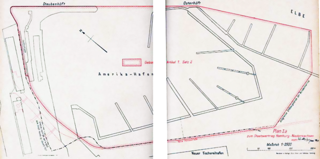
English: Area of the Amerika-Hafen according to the Cuxhaven-Vertrag Deutsch: Gebiet des Amerika-Hafens im Sinne des Cuxhaven-Vertrags |
| Date | |
| Source | Gesetz zum Staatsvertrag mit dem Lande Niedersachsen über die Neuordnung der Rechtsverhältnisse in Cuxhaven und im Gebiet der Elbmündung vom 3. Oktober 1961, ratifiziert am 5. Oktober 1962, in Kraft getreten am 1. Oktober 1969 und bei bei NI-VORIS |
| Author | Hamburg & Niedersachsen |
| Camera location | | View this and other nearby images on: OpenStreetMap |
|---|
| Annotations | This image is annotated: View the annotations at Commons |
Licensing edit
| This image is in the public domain according to German copyright law because it is part of a statute, ordinance, official decree or judgment (official work) issued by a German authority or court (§ 5 Abs.1 UrhG).
|
 |
File history
Click on a date/time to view the file as it appeared at that time.
| Date/Time | Thumbnail | Dimensions | User | Comment | |
|---|---|---|---|---|---|
| current | 23:02, 9 November 2013 | | 1,189 × 591 (834 KB) | Aeroid (talk | contribs) | User created page with UploadWizard |
You cannot overwrite this file.
File usage on Commons
There are no pages that use this file.
File usage on other wikis
The following other wikis use this file:
- Usage on ca.wikipedia.org
- Usage on de.wikipedia.org