File:Cymmer stations site geograph-3363035-by-Ben-Brooksbank.jpg

Size of this preview: 800 × 535 pixels. Other resolutions: 320 × 214 pixels | 640 × 428 pixels | 1,024 × 685 pixels | 1,280 × 856 pixels | 2,354 × 1,575 pixels.
Original file (2,354 × 1,575 pixels, file size: 4.16 MB, MIME type: image/jpeg)
Captions
Captions
Add a one-line explanation of what this file represents
Summary
edit
| Description |
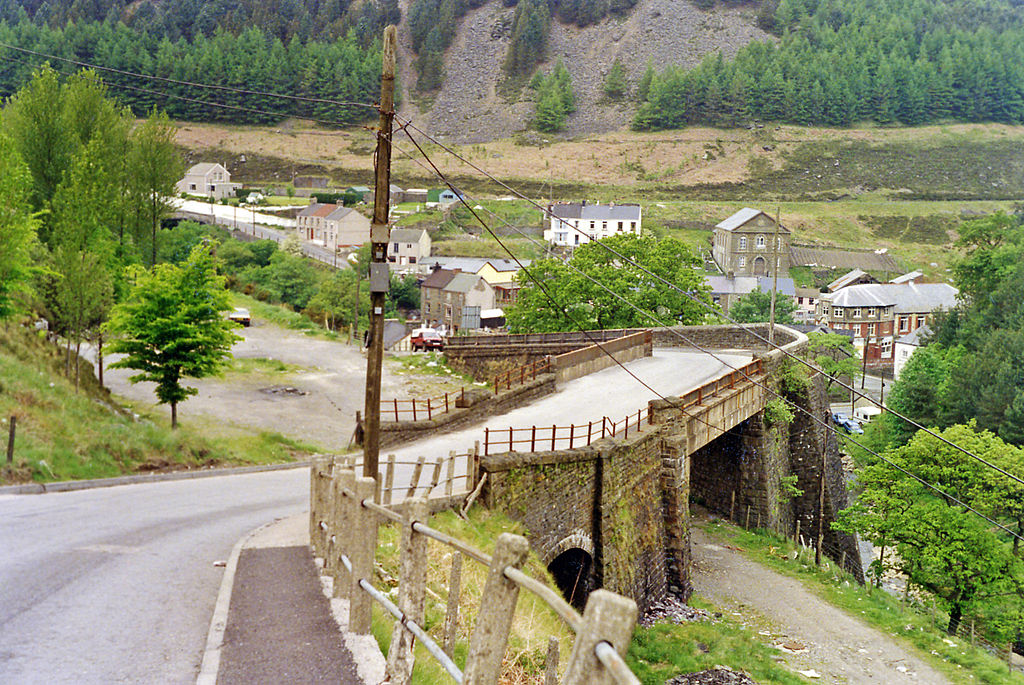
English: Sites of Cymmer stations, 1990. View SW, from A4063 Maesteg road, past the bridge over the trackway of the ex-GWR line from Bridgend via Tondu and Maesteg to Abergwynfi (also Glyncorrwg until 22/9/30). The station (Cymmer General) was to the left and amalgamated in 1/50 with the Rhondda & Swansea Bay Railway Cymmer Afan station, which almost adjoined on the north side. (Some buildings of the Cymmer Afan station may remain intact [?]). The line to Glyncorrwg used to go off up to the right until finally closed on 30/8/65). The line to Abergwynfi closed 13/6/60 and trains diverted to Blaengwynfi (R&SB) until that line closed 26/2/68. Trains from Maesteg finally ceased on 14/7/70. |
| Date | |
| Source | From geograph.org.uk |
| Author | Ben Brooksbank |
| Permission (Reusing this file) |
Creative Commons Attribution Share-alike license 2.0 |
| Attribution (required by the license) | Ben Brooksbank / Sites of Cymmer stations, 1990 / |
| Camera location | | View this and other nearby images on: OpenStreetMap |
|---|
Licensing
edit

|
This image was taken from the Geograph project collection. See this photograph's page on the Geograph website for the photographer's contact details. The copyright on this image is owned by Ben Brooksbank and is licensed for reuse under the Creative Commons Attribution-ShareAlike 2.0 license.
|
This file is licensed under the Creative Commons Attribution-Share Alike 2.0 Generic license.
Attribution: Ben Brooksbank
- You are free:
- to share – to copy, distribute and transmit the work
- to remix – to adapt the work
- Under the following conditions:
- attribution – You must give appropriate credit, provide a link to the license, and indicate if changes were made. You may do so in any reasonable manner, but not in any way that suggests the licensor endorses you or your use.
- share alike – If you remix, transform, or build upon the material, you must distribute your contributions under the same or compatible license as the original.
File history
Click on a date/time to view the file as it appeared at that time.
| Date/Time | Thumbnail | Dimensions | User | Comment | |
|---|---|---|---|---|---|
| current | 09:43, 7 April 2013 | | 2,354 × 1,575 (4.16 MB) | Chevin (talk | contribs) | == {{int:filedesc}} == {{Information |Description={{en|1='''Sites of Cymmer stations, 1990.'''<br/> View SW, from A4063 Maesteg road, past the bridge over the trackway of the ex-GWR line from Bridgend via Tondu and Maesteg to Abergwynfi (also Glyncorrw... |
You cannot overwrite this file.
File usage on Commons
The following page uses this file: