File:Cyprus districts named el.png
Cyprus_districts_named_el.png (600 × 365 pixels, file size: 43 KB, MIME type: image/png)
File information
Structured data
Captions
Captions
Add a one-line explanation of what this file represents
Summary
edit| DescriptionCyprus districts named el.png |
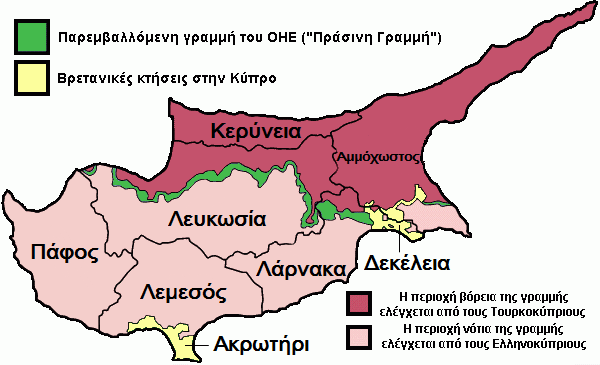
English: Map of the districts of Cyprus with the names and annotations in Greek, and showing the Turkish Occupied by force
Northern Cyprus, United Kingdom Sovereign Base Areas, and United Nations buffer zone.
Ελληνικά: *Χάρτης των περιφερειών της Κύπρου
|
| Date | |
| Source | File:Cyprus districts named.png: By User:Golbez under "GFDL" and "cc-by-sa all" |
| Author | Geraki at Greek Wikipedia |
| Permission (Reusing this file) |
This file is licensed under the Creative Commons Attribution-Share Alike 2.0 Generic license.
|
| Other versions |
Original: File:Cyprus districts named.png The individual maps are: |
Original upload log
editThe original description page was here. All following user names refer to el.wikipedia.
- 2006-02-08 16:33 Geraki 600×365× (20995 bytes) καθάρισμα
- 2005-08-02 14:52 Geraki 600×365× (36715 bytes)
- 2005-08-02 14:49 Geraki 600×365× (61209 bytes)
File history
Click on a date/time to view the file as it appeared at that time.
| Date/Time | Thumbnail | Dimensions | User | Comment | |
|---|---|---|---|---|---|
| current | 15:08, 30 April 2016 |  | 600 × 365 (43 KB) | Neo ^ (talk | contribs) | Σωστή ορθογραφία: Κερύνεια |
| 11:35, 11 June 2014 |  | 600 × 365 (45 KB) | Κωνσταντίνος13 (talk | contribs) | Bigger letters | |
| 20:16, 25 June 2009 |  | 600 × 365 (21 KB) | File Upload Bot (Magnus Manske) (talk | contribs) | {{BotMoveToCommons|el.wikipedia|year={{subst:CURRENTYEAR}}|month={{subst:CURRENTMONTHNAME}}|day={{subst:CURRENTDAY}}}} {{Information |Description={{el|*Χάρτης των περιφερειών της Κύπρου *Η ελεγχόμενη από τον |
You cannot overwrite this file.
File usage on Commons
The following page uses this file:
File usage on other wikis
The following other wikis use this file:
- Usage on el.wikipedia.org
Metadata
This file contains additional information such as Exif metadata which may have been added by the digital camera, scanner, or software program used to create or digitize it. If the file has been modified from its original state, some details such as the timestamp may not fully reflect those of the original file. The timestamp is only as accurate as the clock in the camera, and it may be completely wrong.
| Horizontal resolution | 37.8 dpc |
|---|---|
| Vertical resolution | 37.8 dpc |
