File:Déluge Saguenay Accumulations.png
Size of this preview: 492 × 599 pixels. Other resolutions: 197 × 240 pixels | 500 × 609 pixels.
Original file (500 × 609 pixels, file size: 206 KB, MIME type: image/png)
Captions
Captions
Add a one-line explanation of what this file represents
Summary
edit
| Description |
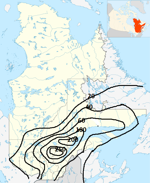
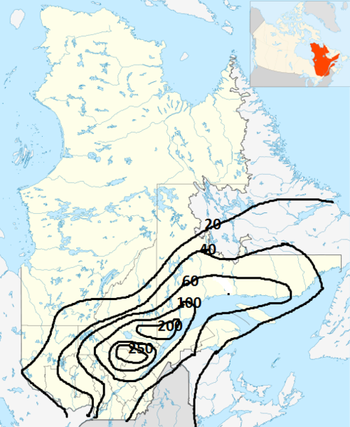
English: Map of rain accumulations from July 18 to 21, 1996, over Quebec province (Canada) during the Saguenay Flood. Maps is done using Canada_Quebec_location_map_2.svg blanck map and data from Environnement public page at http://www.climat-quebec.qc.ca/htdocs/data_fixe/page/fr/p_suivi_climatologique/p_evenements_exceptionnels/SurvoldesCasPluiesAbondantes.pdf
Français : Cartes des accumulations du 18 au 21 juillet 1996 lors de l'épisode du Déluge du Saguenay. La carte est faite à partir de la carte vierge Canada_Quebec_location_map_2.svg et des données du site public de Environnement Canada à http://www.climat-quebec.qc.ca/htdocs/data_fixe/page/fr/p_suivi_climatologique/p_evenements_exceptionnels/SurvoldesCasPluiesAbondantes.pdf |
| Date | |
| Source | Own work |
| Author | Pierre cb |
Licensing
edit
I, the copyright holder of this work, hereby publish it under the following license:
| This file is made available under the Creative Commons CC0 1.0 Universal Public Domain Dedication. | |
| The person who associated a work with this deed has dedicated the work to the public domain by waiving all of their rights to the work worldwide under copyright law, including all related and neighboring rights, to the extent allowed by law. You can copy, modify, distribute and perform the work, even for commercial purposes, all without asking permission.
|
File history
Click on a date/time to view the file as it appeared at that time.
| Date/Time | Thumbnail | Dimensions | User | Comment | |
|---|---|---|---|---|---|
| current | 04:48, 14 August 2011 | | 500 × 609 (206 KB) | Pierre cb (talk | contribs) | {{Information |Description ={{en|1=Map of rain accumulations from July 18 to 21, 1996, over Quebec province (Canada) during the Saguenay Flood. Maps is done using Canada_Quebec_location_map_2.svg blanck map and dat |
You cannot overwrite this file.
File usage on Commons
There are no pages that use this file.
File usage on other wikis
The following other wikis use this file:
- Usage on en.wikipedia.org
- Usage on fr.wikipedia.org