File:D-Day slipway, Torquay - geograph.org.uk - 821336.jpg

Size of this preview: 450 × 600 pixels. Other resolutions: 180 × 240 pixels | 480 × 640 pixels.
Original file (480 × 640 pixels, file size: 65 KB, MIME type: image/jpeg)
Captions
Captions
Add a one-line explanation of what this file represents
Summary
edit
| Description |
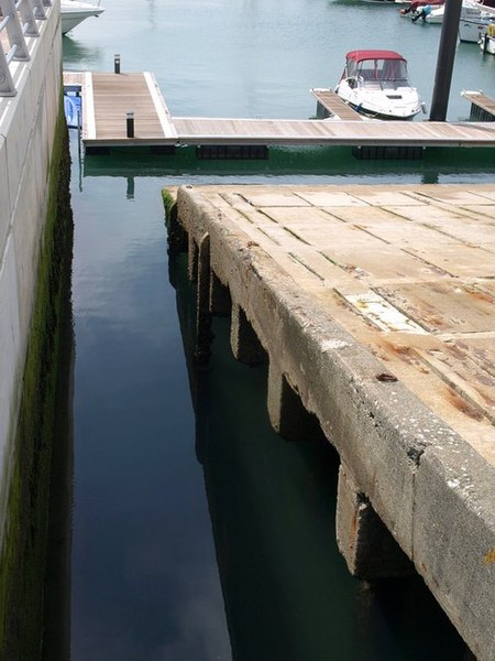
English: D-Day slipway, Torquay. One of a pair of slipways, built in May 1943 by the Royal Engineers for D-Day embarkation of troops, and of which there are several remaining examples on the south coast. "However, of all these embarkation sites, the substantial concrete slipways at Torquay stand out, dominating the modern harbour. Surprisingly, they are not advertised in any way and their historical significance is not obvious to the many visitors the town attracts. In fact the men of the 77th Infantry Division, destined for Utah Beach, embarked from here, and it is here every four years that the Normandy Veterans hold a commemoration service on the harbourside at the head of the slips ... To coincide with the 56th anniversary of embarkation, on 6 June 2000, these structures were afforded protection by the Secretary of State, much to the delight of the veterans. Thus the Torquay slips now have recognition as structures of particular importance for commemorative and historic reasons." (From Matériel Culture: The Archaeology of 20th Century Conflict, by A. J. Schofield, William Gray Johnson, Colleen M. Beck).
In spite of their grade II listing, the slipways remained under threat of demolition during the early years of this decade, but now seem safe. Beyond is part of the pontoon shown in 820898. The sea wall on the left is also recent. |
| Date | |
| Source | From geograph.org.uk |
| Author | Derek Harper |
| Attribution (required by the license) | Derek Harper / D-Day slipway, Torquay / |
| Camera location | | View this and other nearby images on: OpenStreetMap |
|---|
_heading:270.00&language=en)
| Object location | | View this and other nearby images on: OpenStreetMap |
|---|
_heading:270.00&language=en)
Licensing
edit

|
This image was taken from the Geograph project collection. See this photograph's page on the Geograph website for the photographer's contact details. The copyright on this image is owned by Derek Harper and is licensed for reuse under the Creative Commons Attribution-ShareAlike 2.0 license.
|
This file is licensed under the Creative Commons Attribution-Share Alike 2.0 Generic license.
Attribution: Derek Harper
- You are free:
- to share – to copy, distribute and transmit the work
- to remix – to adapt the work
- Under the following conditions:
- attribution – You must give appropriate credit, provide a link to the license, and indicate if changes were made. You may do so in any reasonable manner, but not in any way that suggests the licensor endorses you or your use.
- share alike – If you remix, transform, or build upon the material, you must distribute your contributions under the same or compatible license as the original.
File history
Click on a date/time to view the file as it appeared at that time.
| Date/Time | Thumbnail | Dimensions | User | Comment | |
|---|---|---|---|---|---|
| current | 15:22, 20 February 2011 | | 480 × 640 (65 KB) | GeographBot (talk | contribs) | == {{int:filedesc}} == {{Information |description={{en|1=D-Day slipway, Torquay One of a pair of slipways, built in May 1943 by the Royal Engineers for D-Day embarkation of troops, and of which there are several remaining examples on the south coast. "How |
You cannot overwrite this file.
File usage on Commons
There are no pages that use this file.