File:DEU Landkreis Berchtesgadener Land COA.svg

Size of this PNG preview of this SVG file: 569 × 600 pixels. Other resolutions: 228 × 240 pixels | 456 × 480 pixels | 729 × 768 pixels | 972 × 1,024 pixels | 1,944 × 2,048 pixels | 708 × 746 pixels.
Original file (SVG file, nominally 708 × 746 pixels, file size: 41 KB)
Captions
Captions
Add a one-line explanation of what this file represents
Summary edit
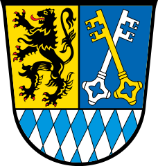
| Coat of arms | Deutsch: von Landkreis Berchtesgadener Land English: of the municipality of Landkreis Berchtesgadener Land |
|||||
| Blazon | Deutsch: Über Schildfuß mit den bayerischen Rauten gespalten von Gold und Blau; vorne ein rot bewehrter schwarzer Löwe, hinten schräg gekreuzt ein goldener und ein silberner Schlüssel. |
|||||
| Blazon reference | ||||||
| Tincture (BY) | argentorcélestegulessable |
|||||
| Date | from 1973; SVG 22 October 2020 | |||||
| Object history | Die Symbole im Wappen spiegeln die herrschaftsgeschichtliche Zusammensetzung des heutigen Landkreises wider, der 1972 aus der ehemals kreisfreien Stadt Bad Reichenhall, dem bisherigen Landkreis Berchtesgaden und dem südlichen Teil des Landkreises Laufen gebildet wurde. Die bayerischen Rauten im Schildfuß weisen auf die frühe enge herrschaftsgeschichtliche Verbindung des Hauses Wittelsbach mit dem Raum um Bad Reichenhall hin, wo die Interessen mit denen des Fürststifts Salzburg zusammentrafen. Der rot bewehrte schwarze Löwe stammt aus der Heraldik des Hochstifts Salzburg und erinnert daran, dass das Gebiet um Laufen bis zur Eingliederung nach Bayern 1810 zum Herrschaftsbereich des Salzburger Fürsterzbischofs gehörte. Die gekreuzten Schlüssel, Attribut des heiligen Petrus, versinnbildlichen den Patron der Fürstpropstei Berchtesgaden, die ebenfalls erst 1810 zu Bayern kam. Die Rauten im Schildfuß symbolisieren damit auch die einheitliche Zugehörigkeit des heutigen Kreisgebiets zum Königreich bzw. Freistaat Bayern seit dem 19. Jahrhundert. Die Petrusschlüssel sind aus dem bis 1972 geltenden Berchtesgadener Landkreiswappen, die Rauten aus dem Wappen der Stadt Bad Reichenhall übernommen. Der neue Landkreis mit Sitz des Landratsamtes in Bad Reichenhall führte bis 1973 den vorläufigen Namen Bad Reichenhall und wurde dann in Berchtesgadener Land umbenannt. | |||||
| Artist | Original: Unknown Vector: |
|||||
| Source | Own work based on: Wappen Landkreis Berchtesgadener Land.png | |||||
| Permission (Reusing this file) |
|
|||||
| Other versions |
|
|||||
| SVG development |


File history
Click on a date/time to view the file as it appeared at that time.
| Date/Time | Thumbnail | Dimensions | User | Comment | |
|---|---|---|---|---|---|
| current | 09:27, 26 October 2022 | | 708 × 746 (41 KB) | Maxwxyz (talk | contribs) | Clean up and correct colors BY |
| 15:03, 18 July 2022 |  | 708 × 746 (55 KB) | Maxwxyz (talk | contribs) | Clean up and correct colors | |
| 14:00, 19 June 2022 |  | 708 × 746 (55 KB) | Maxwxyz (talk | contribs) | Clean up and correct colors | |
| 06:10, 22 October 2020 |  | 708 × 746 (55 KB) | Chris die Seele (talk | contribs) | Korrektur basierend auf amtlich geführtem Wappen der Gemeinde. Korrektur der Tingierung. | |
| 07:23, 10 February 2017 |  | 708 × 746 (40 KB) | Chris die Seele (talk | contribs) | User created page with UploadWizard |
You cannot overwrite this file.
File usage on Commons
The following 46 pages use this file:
- Landkreis Berchtesgadener Land
- File:DEU Landkreis Berchtesgadener Land COA.svg
- File:Schwarzbachloch.JPG
- File:Schwarzbachschlucht.jpg
- File:Wappen Landkreis Berchtesgadener Land.png
- Template:Municipalities in Landkreis Berchtesgadener Land
- Category:Ainring
- Category:Anger (Berchtesgadener Land)
- Category:Bad Reichenhall
- Category:Badeanlage im Landkreis Berchtesgadener Land
- Category:Bayerisch Gmain
- Category:Berchtesgaden
- Category:Bischofswiesen
- Category:Christianity in Landkreis Berchtesgadener Land
- Category:Districts of Ainring
- Category:Districts of Anger (Berchtesgadener Land)
- Category:Districts of Bad Reichenhall
- Category:Districts of Berchtesgaden
- Category:Districts of Bischofswiesen
- Category:Districts of Freilassing
- Category:Districts of Laufen (Salzach)
- Category:Districts of Marktschellenberg
- Category:Districts of Piding
- Category:Districts of Ramsau bei Berchtesgaden
- Category:Districts of Teisendorf
- Category:Eck (gemeindefreies Gebiet)
- Category:Economy of Landkreis Berchtesgadener Land
- Category:Freilassing
- Category:Landkreis Berchtesgadener Land
- Category:Laufen (Salzach)
- Category:Maps of Landkreis Berchtesgadener Land
- Category:Marktschellenberg
- Category:Mountains of Landkreis Berchtesgadener Land
- Category:Nature reserves in Landkreis Berchtesgadener Land
- Category:People of Landkreis Berchtesgadener Land
- Category:Piding
- Category:Ramsau bei Berchtesgaden
- Category:Religion in Landkreis Berchtesgadener Land
- Category:Saaldorf-Surheim
- Category:Schellenberger Forst
- Category:Schneizlreuth
- Category:Schönau am Königssee
- Category:Stairs in Bad Reichenhall
- Category:Street furniture in Berchtesgaden
- Category:Teisendorf
- Category:Views of Landkreis Berchtesgadener Land
File usage on other wikis
The following other wikis use this file:
- Usage on an.wikipedia.org
- Usage on ar.wikipedia.org
- Usage on be.wikipedia.org
- Usage on ca.wikipedia.org
- Usage on ceb.wikipedia.org
- Usage on cs.wikipedia.org
- Usage on da.wikipedia.org
- Usage on de.wikipedia.org
View more global usage of this file.