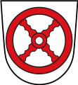
File:DEU Melle COA.svg

Size of this PNG preview of this SVG file: 412 × 472 pixels. Other resolutions: 209 × 240 pixels | 419 × 480 pixels | 670 × 768 pixels | 894 × 1,024 pixels | 1,788 × 2,048 pixels.
Original file (SVG file, nominally 412 × 472 pixels, file size: 3 KB)
File information
Structured data
Captions
Captions
Add a one-line explanation of what this file represents
Summary
edit| Coat of arms InfoField | Français : de la ville allemande de Melle |
| Blazon InfoField | Deutsch: „Die Stadt Melle führt als Wappen ein vierspeichiges rotes Rad mit schräger Speichenstellung auf einem silbernen Schild.“Heraldisch besser:„In Silber ein rotes Rad mit vier schräggekreuzten Speichen.“ English: “Argent a wheel spoked of four in saltire Gules.” Français : « D'argent à la roue à quatre rayons en sautoir de gueules. » |
| Blazon reference InfoField | Deutsch: §1 der Hauptsatzung der Stadt Melle |
| Tincture InfoField | argentgules |
| Date |
Deutsch: zuletzt verliehen 1964 English: last granted in 1964 Français : décoré en dernier 1964 |
| Object history |
Deutsch: Das erstmals 1939 durch preußischen Ministerialerlass und 1964 vom niedersächsischen Innenministerium zuletzt genehmigte Wappen ist abgeleitet vom Wappen des Bistums Osnabrück, welches sechs Speichen zeigt. English: The arms were officially granted in 1939 and confirmed in 1964. They are derived from the arms of the Diocese of Osnabrück. |
| Artist InfoField | |
| Source | Website der Stadt Melle |
| Other versions |
 |
| SVG development InfoField |
Licensing
edit| Public domainPublic domainfalsefalse |
This file depicts the coat of arms of a German Körperschaft des öffentlichen Rechts (corporation governed by public law). According to § 5 Abs. 1 of the German Copyright law, official works like coats of arms are in the public domain.
Note: The usage of coats of arms is governed by legal restrictions, independent of the copyright status of the depiction shown here.
|
 |
| Object location | 52° 12′ 11″ N, 8° 20′ 10″ E | View this and other nearby images on: OpenStreetMap |
|---|
File history
Click on a date/time to view the file as it appeared at that time.
| Date/Time | Thumbnail | Dimensions | User | Comment | |
|---|---|---|---|---|---|
| current | 10:10, 5 August 2016 |  | 412 × 472 (3 KB) | Jürgen Krause (talk | contribs) | redrawn refered to city charta - https://www.melle.info/downloads/datei/OTE5MDAwMjE5Oy07L3Vzci9sb2NhbC9odHRwZC92aHRkb2NzL21lbGxlL21lbGxlL21lZGllbi9kb2t1bWVudGUvMTBfMV9oYXVwdHNhdHp1bmdfMjAxMS4xMS4wMi5wZGY%3D/10_1_hauptsatzung_2011.11.02.pdf |
| 12:23, 5 June 2009 |  | 500 × 541 (12 KB) | Hagar66 (talk | contribs) | {{Information |Description= |Source= |Date= |Author= |Permission= |other_versions= }} | |
| 11:55, 5 June 2009 |  | 500 × 541 (511 bytes) | Hagar66 (talk | contribs) | {{COAInformation |blasonde=Stadt Melle |blasonnement-de=„Vierspeichiges rotes Rad mit schräger Speichenstellung auf einem silbernen (weißen) Schild“ |ref-de= |blasonen=city of [[:Category:Melle (Lower Saxony)|Melle |
You cannot overwrite this file.
File usage on Commons
The following 39 pages use this file:
- File:Banner Melle.svg
- File:DEU Melle COA.svg
- File:DE Melle COA.svg (file redirect)
- File:Flagge Melle.svg
- File:Stadtwappen Melle.svg
- File:WappenMelle.jpg
- File:Wappen Melle.png
- Template:Melle (Lower Saxony)year
- Template:Melle decade
- Category:1945 in Melle (Lower Saxony)
- Category:1999 in Melle (Lower Saxony)
- Category:2000 in Melle (Lower Saxony)
- Category:2001 in Melle (Lower Saxony)
- Category:2003 in Melle (Lower Saxony)
- Category:2004 in Melle (Lower Saxony)
- Category:2005 in Melle (Lower Saxony)
- Category:2006 in Melle (Lower Saxony)
- Category:2007 in Melle (Lower Saxony)
- Category:2008 in Melle (Lower Saxony)
- Category:2009 in Melle (Lower Saxony)
- Category:2010 in Melle (Lower Saxony)
- Category:2011 in Melle (Lower Saxony)
- Category:2012 in Melle (Lower Saxony)
- Category:2013 in Melle (Lower Saxony)
- Category:2014 in Melle (Lower Saxony)
- Category:2015 in Melle (Lower Saxony)
- Category:2016 in Melle (Lower Saxony)
- Category:2017 in Melle (Lower Saxony)
- Category:2018 in Melle (Lower Saxony)
- Category:2019 in Melle (Lower Saxony)
- Category:2020 in Melle (Lower Saxony)
- Category:2021 in Melle (Lower Saxony)
- Category:2022 in Melle (Lower Saxony)
- Category:2023 in Melle (Lower Saxony)
- Category:Melle (Lower Saxony) in the 1940s
- Category:Melle (Lower Saxony) in the 1990s
- Category:Melle (Lower Saxony) in the 2000s
- Category:Melle (Lower Saxony) in the 2010s
- Category:Melle (Lower Saxony) in the 2020s
File usage on other wikis
The following other wikis use this file:
- Usage on azb.wikipedia.org
- Usage on da.wikipedia.org
- Usage on de.wikipedia.org
- Usage on es.wikipedia.org
- Usage on et.wikipedia.org
- Usage on fa.wikipedia.org
- Usage on id.wikipedia.org
- Usage on it.wikipedia.org
- Usage on ja.wikipedia.org
- Usage on lv.wikipedia.org
- Usage on ms.wikipedia.org
- Usage on nl.wikipedia.org
- Usage on pl.wikipedia.org
- Usage on pt.wikipedia.org
- Usage on ru.wikipedia.org
- Usage on sh.wikipedia.org
- Usage on sr.wikipedia.org
- Usage on sv.wikipedia.org
- Usage on tr.wikipedia.org
- Usage on uk.wikipedia.org
- Usage on vi.wikipedia.org
- Usage on vo.wikipedia.org
Metadata
This file contains additional information such as Exif metadata which may have been added by the digital camera, scanner, or software program used to create or digitize it. If the file has been modified from its original state, some details such as the timestamp may not fully reflect those of the original file. The timestamp is only as accurate as the clock in the camera, and it may be completely wrong.
| Width | 412 |
|---|---|
| Height | 472 |