File:DOOR TO DRIVE MECHANISM SHOWING MANUFACTURING INFORMATION - Point Reyes Lighthouse, Point Reyes Station, Marin County, CA HABS CAL,21-POREY,1-6.tif

Size of this JPG preview of this TIF file: 483 × 600 pixels. Other resolutions: 193 × 240 pixels | 386 × 480 pixels | 618 × 768 pixels | 825 × 1,024 pixels | 1,649 × 2,048 pixels | 4,027 × 5,000 pixels.
Original file (4,027 × 5,000 pixels, file size: 19.2 MB, MIME type: image/tiff)
Captions
Captions
Add a one-line explanation of what this file represents
Summary edit
| DOOR TO DRIVE MECHANISM SHOWING MANUFACTURING INFORMATION - Point Reyes Lighthouse, Point Reyes Station, Marin County, CA | ||||
|---|---|---|---|---|
| Title |
DOOR TO DRIVE MECHANISM SHOWING MANUFACTURING INFORMATION - Point Reyes Lighthouse, Point Reyes Station, Marin County, CA |
|||
| Depicted place | California; Marin County; Point Reyes Station | |||
| Date | Documentation compiled after 1933 | |||
| Dimensions | 4 x 5 in. | |||
| Current location |
Library of Congress Prints and Photographs Division Washington, D.C. 20540 USA http://hdl.loc.gov/loc.pnp/pp.print |
|||
| Accession number |
HABS CAL,21-POREY,1-6 |
|||
| Credit line |
|
|||
| Notes |
|
|||
| References |
|
|||
| Source | https://www.loc.gov/pictures/item/ca1357.photos.013087p | |||
| Permission (Reusing this file) |
|
|||

| Object location | | View this and other nearby images on: OpenStreetMap |
|---|
File history
Click on a date/time to view the file as it appeared at that time.
| Date/Time | Thumbnail | Dimensions | User | Comment | |
|---|---|---|---|---|---|
| current | 01:26, 3 July 2014 | 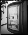 | 4,027 × 5,000 (19.2 MB) | Fæ (talk | contribs) | GWToolset: Creating mediafile for Fæ. HABS batch upload 2 July 2014 (301:400) |
You cannot overwrite this file.
File usage on Commons
The following page uses this file: