File:David de Meyne2.jpg

Size of this preview: 800 × 599 pixels. Other resolutions: 320 × 239 pixels | 640 × 479 pixels | 1,024 × 766 pixels | 1,280 × 958 pixels | 1,506 × 1,127 pixels.
Original file (1,506 × 1,127 pixels, file size: 1.9 MB, MIME type: image/jpeg)
Captions
Captions
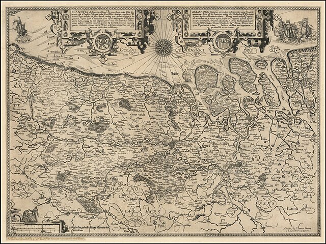
Flandria ditissimus, fertilissimus, & amoenissimus totius orbis Comitatus/ Zelandiae Comitatus, septemdecim inferioris Germaniae Provincijs annumeratur, Arnold & Henricus Van Langren / David De Meyne, c. 1597/1610, Amsterdam, 21.5 x 16 inches
Summary
edit
| Description |
English: [Flanders & Zeeland] Flandria ditissimus, fertilissimus, & amoenissimus totius orbis Comitatus . . . / Zelandiae Comitatus, septemdecim inferioris Germaniae Provincijs annumeratur . . ., Arnold Van Langren / Henricus Van Langren / David De Meyne, c. 1597/1610, Amsterdam, 21.5 x 16 inches. Third state of the Van Langren map of Flanders and Zeeland, published in Amsterdam in about 1610 by David de Meyne |
| Date | c. 1595/1610 |
| Source | https://www.raremaps.com/mapmaker/4373/David_De_Meyne |
| Author | David de Meyne |
Licensing
edit
This file is licensed under the Creative Commons Attribution-Share Alike 4.0 International license.
- You are free:
- to share – to copy, distribute and transmit the work
- to remix – to adapt the work
- Under the following conditions:
- attribution – You must give appropriate credit, provide a link to the license, and indicate if changes were made. You may do so in any reasonable manner, but not in any way that suggests the licensor endorses you or your use.
- share alike – If you remix, transform, or build upon the material, you must distribute your contributions under the same or compatible license as the original.
File history
Click on a date/time to view the file as it appeared at that time.
| Date/Time | Thumbnail | Dimensions | User | Comment | |
|---|---|---|---|---|---|
| current | 09:15, 26 May 2022 | | 1,506 × 1,127 (1.9 MB) | Sigfrøðr (talk | contribs) | Uploaded a work by David de Meyne from https://www.raremaps.com/mapmaker/4373/David_De_Meyne with UploadWizard |
You cannot overwrite this file.
File usage on Commons
There are no pages that use this file.