File:Day in the Williams Ranger District Map (48832744307).png

Original file (3,016 × 4,663 pixels, file size: 1.25 MB, MIME type: image/png)
Captions
Captions
Summary
edit.png&action=edit§ion=1)
| Description |
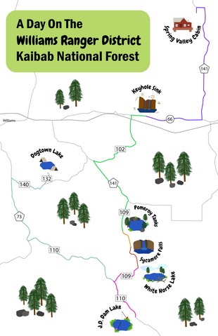
Have a day in the Williams Ranger District? Follow this handy map to check out some of the best recreation and lodging spots in the area. Start your night at Spring Valley Cabin, then venture down County Road 141 to Route 66 and on to Keyhole Sink. After a quick hike, proceed down Forest Road 102, make a left on County Road 141, and make a right on Forest Road 109. Along Forest Road 109, you'll come along Pomeroy Tanks Trail, Sycamore Falls Trail, and White Horse Lake and Campground. Chow down a quick lakeside lunch, then head down Forest Road 110 to J.D. Dam Lake for a tranquil afternoon at this popular fishing spot. Finally, take Forest Road 110 to County Road 73, then make a right on Forest Road 140 and a left on Forest Road 132. There, you will find Dogtown Lake and Campground, a peaceful place to end your long day of recreating. Graphic designed by Adriana Petrungaro. Credit Kaibab National Forest. |
| Date | |
| Source | Day in the Williams Ranger District Map |
| Author | Kaibab National Forest |
Licensing
edit.png&action=edit§ion=2)
This image or file is a work of a United States Department of Agriculture employee, taken or made as part of that person's official duties. As a work of the U.S. federal government, the image is in the public domain.
|
 |
File history
Click on a date/time to view the file as it appeared at that time.
| Date/Time | Thumbnail | Dimensions | User | Comment | |
|---|---|---|---|---|---|
| current | 01:25, 21 November 2019 | | 3,016 × 4,663 (1.25 MB) | Ser Amantio di Nicolao (talk | contribs) | Transferred from Flickr via #flickr2commons |
You cannot overwrite this file.
File usage on Commons
There are no pages that use this file.
.png&oldid=887045432)