File:De Cust van Westindien Tußchen Punta St. Blaes, en Punta d Naes - Beschreven door A. Roggeveen - btv1b53122171h (1 of 2).jpg

Size of this preview: 777 × 600 pixels. Other resolutions: 311 × 240 pixels | 622 × 480 pixels | 995 × 768 pixels | 1,280 × 988 pixels | 2,560 × 1,976 pixels | 7,174 × 5,538 pixels.
Original file (7,174 × 5,538 pixels, file size: 4.55 MB, MIME type: image/jpeg)
Captions
Captions
Add a one-line explanation of what this file represents
Summary
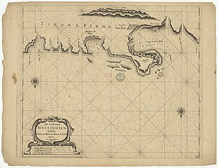
edit| De Cust van Westindien Tußchen Punta St. Blaes, en Punta d Naes / Beschreven door A. Roggeveen
( |
|||||||||||||||||||||||||||
|---|---|---|---|---|---|---|---|---|---|---|---|---|---|---|---|---|---|---|---|---|---|---|---|---|---|---|---|
| Author |
Roggeveen, Arent (16..-1679). Cartographe |
||||||||||||||||||||||||||
| Title |
De Cust van Westindien Tußchen Punta St. Blaes, en Punta d Naes / Beschreven door A. Roggeveen |
||||||||||||||||||||||||||
| Description |
Français : Sujet : Portobelo, Baie de
San Blas, Punta (cap) Échelle(s) : Duytschen Mylen 15 in een Graad, 5 [= 10 cm] Couverture : Panama Langue : néerlandais Éditeur : J. Robyn |
||||||||||||||||||||||||||
| Date | 17th century - 18th century | ||||||||||||||||||||||||||
| Dimensions | height: 50 cm (19.6 in); width: 43 cm (16.9 in) | ||||||||||||||||||||||||||
| Collection |
|
||||||||||||||||||||||||||
| References |
Français : Notice de recueil : http://catalogue.bnf.fr/ark:/12148/cb44212495p
Appartient à : [Division 2 du portefeuille 161 du Service hydrographique de la marine consacrée à la Colombie et au Venezuela ] ; 10 D Notice du catalogue : http://catalogue.bnf.fr/ark:/12148/cb44213011z |
||||||||||||||||||||||||||
| Source/Photographer |
Français : Bibliothèque nationale de France, département Cartes et plans, GE SH 18 PF 161 DIV 2 P 10 D
Bibliothèque nationale de France (1/2) |
||||||||||||||||||||||||||
| Permission (Reusing this file) |
|
||||||||||||||||||||||||||

.jpg&action=edit§ion=1)
File history
Click on a date/time to view the file as it appeared at that time.
| Date/Time | Thumbnail | Dimensions | User | Comment | |
|---|---|---|---|---|---|
| current | 22:36, 14 July 2022 | | 7,174 × 5,538 (4.55 MB) | Gzen92Bot (talk | contribs) | Gallica btv1b53122171h |
You cannot overwrite this file.
File usage on Commons
The following page uses this file:
.jpg)
.jpg&oldid=825758118)