File:De Fer Cette Carte de Californie et du Nouveau Mexique 1705 UTA.jpg
Size of this preview: 800 × 544 pixels. Other resolutions: 320 × 217 pixels | 640 × 435 pixels | 1,024 × 696 pixels | 1,180 × 802 pixels.
Original file (1,180 × 802 pixels, file size: 271 KB, MIME type: image/jpeg)
Captions
Captions
Add a one-line explanation of what this file represents
Summary
edit| Title |
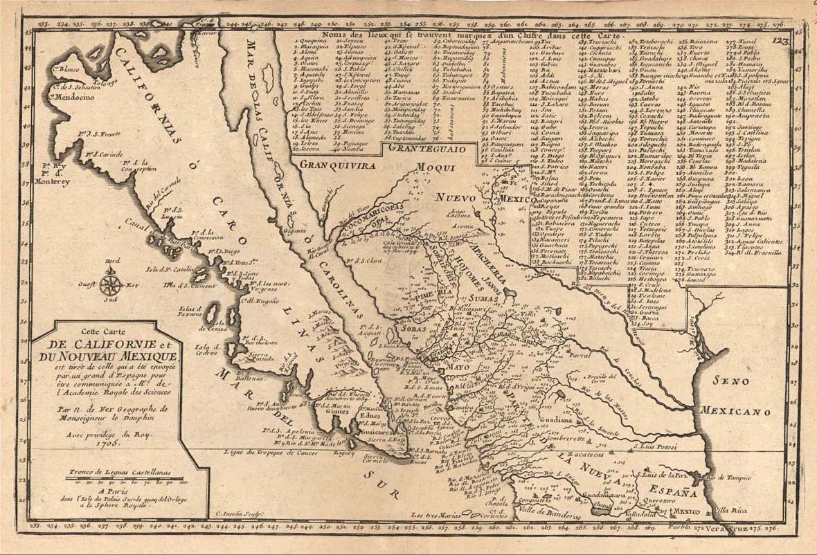
Français : Cette carte de Californie et du Nouveau Mexique, est tirée de celle que a èté envoyée par un grand d'Espagne pour être communiquée a Mrs. de l'Academie Royale des Sciences |
||||||||||||||||||||||||||||||||||||||||
| Description |
English: Engraving by Charles Inselin.
The map's title translates roughly "This map of California and New Mexico is taken from one that was sent by an important Spaniard to be communicated to members of the Royal Academy of Sciences." The manuscript map in question was a copy of a 1695-1696 map drawn by the Jesuit priest and missionary Father Eusebio Kino, who, by that time had traveled over much of northern New Spain yet still believed that California was an island. Kino's map had a great deal of new and reliable information about Spanish missions and settlements, including sites along the upper reaches of the Rio Grande in present Chihuahua and far west Texas. As noted in Fer's title, a Spanish nobleman forwarded a copy of Kino's 1695-1696 map to the French Royal Academy of Sciences where in 1700 de Fer and engraver Charles Inselin copied it without crediting Kino. De Fer and Inselin rearranged Kino's map with a numbering system and keyed list and, in so doing, failed to transfer all the sites and names with complete accuracy. Although de Fer's map was an improvement for its time, the map was quickly superseded by other printed maps based on a more famous 1701 manuscript map by Kino that showed California as a peninsula. |
||||||||||||||||||||||||||||||||||||||||
| Date | |||||||||||||||||||||||||||||||||||||||||
| Source | UTA Libraries Cartographic Connections: map / text | ||||||||||||||||||||||||||||||||||||||||
| Creator |
|
||||||||||||||||||||||||||||||||||||||||
| Credit line |
English: UTA Libraries Special Collections |
||||||||||||||||||||||||||||||||||||||||
| Geotemporal data | |||||||||||||||||||||||||||||||||||||||||
| Map location | New Spain | ||||||||||||||||||||||||||||||||||||||||
| Georeferencing | If inappropriate please set warp_status = skip to hide. | ||||||||||||||||||||||||||||||||||||||||
| Bibliographic data | |||||||||||||||||||||||||||||||||||||||||
| Place of publication | Paris | ||||||||||||||||||||||||||||||||||||||||
| Printed by |
|
||||||||||||||||||||||||||||||||||||||||
| Archival data | |||||||||||||||||||||||||||||||||||||||||
| Collection |
|
||||||||||||||||||||||||||||||||||||||||
| Medium | engraving | ||||||||||||||||||||||||||||||||||||||||
| artwork-references |
Burrus, Ernest J. (1965) Kino and the Cartography of Northwestern New Spain, Tucson: Arizona Pioneers' Historical Society, no. VIII Warren, Bill (July/August 2002). "Mapmaker on a Mission[: Father Kino and the Myth of Insular California]". Mercator's World 7 (4). |
||||||||||||||||||||||||||||||||||||||||


Licensing
edit

|
This file was provided to Wikimedia Commons by the University of Texas at Arlington Libraries as part of a cooperation project. The University of Texas at Arlington Libraries is part of the University of Texas at Arlington, a public research university located in Arlington, Texas.
|
|
The author died in 1720, so this work is in the public domain in its country of origin and other countries and areas where the copyright term is the author's life plus 100 years or fewer. This work is in the public domain in the United States because it was published (or registered with the U.S. Copyright Office) before January 1, 1929. | |
| This file has been identified as being free of known restrictions under copyright law, including all related and neighboring rights. | |
File history
Click on a date/time to view the file as it appeared at that time.
| Date/Time | Thumbnail | Dimensions | User | Comment | |
|---|---|---|---|---|---|
| current | 20:52, 10 February 2022 | | 1,180 × 802 (271 KB) | Michael Barera (talk | contribs) | == {{int:filedesc}} == {{Map |title = {{fr|'''''Cette carte de Californie et du Nouveau Mexique, est tirée de celle que a èté envoyée par un grand d'Espagne pour être communiquée a Mrs. de l'Academie Royale des Sciences'''''}} |description = {{en|Engraving by Charles Inselin. The map's title translates roughly "This map of California and New Mexico is taken from one that was sent by an important Spaniard to be communicated to members of the Royal Academy of Sciences." The... |
You cannot overwrite this file.
File usage on Commons
The following page uses this file: