File:Deception Island Map.svg

Size of this PNG preview of this SVG file: 644 × 599 pixels. Other resolutions: 258 × 240 pixels | 516 × 480 pixels | 825 × 768 pixels | 1,101 × 1,024 pixels | 2,201 × 2,048 pixels | 820 × 763 pixels.
Original file (SVG file, nominally 820 × 763 pixels, file size: 461 KB)
Captions
Captions
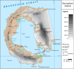
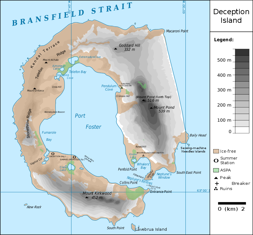
Map of Deception Island, Antarctica
| Description |
Français : carte de l'île de la Déception avec les toponymes + la position des stations ainsi que des zones protégées
English: map of Deception Island with the topography and the location of the stations and protected zones |
| Date | (UTC) |
| Source | |
| Author |
|
| This is a retouched picture, which means that it has been digitally altered from its original version. The original can be viewed here: Ile de la Deception.svg:
|
I, the copyright holder of this work, hereby publish it under the following licenses:
This file is licensed under the Creative Commons Attribution 3.0 Unported license.
- You are free:
- to share – to copy, distribute and transmit the work
- to remix – to adapt the work
- Under the following conditions:
- attribution – You must give appropriate credit, provide a link to the license, and indicate if changes were made. You may do so in any reasonable manner, but not in any way that suggests the licensor endorses you or your use.

|
Permission is granted to copy, distribute and/or modify this document under the terms of the GNU Free Documentation License, Version 1.2 or any later version published by the Free Software Foundation; with no Invariant Sections, no Front-Cover Texts, and no Back-Cover Texts. A copy of the license is included in the section entitled GNU Free Documentation License. |
You may select the license of your choice.
Original upload log edit
This image is a derivative work of the following images:
- File:Ile_de_la_Deception.svg licensed with Cc-by-3.0, GFDL
- 2010-06-19T09:08:35Z Treehill 820x763 (464885 Bytes) carrés noirs (tentative)
- 2010-06-18T17:48:51Z Treehill 820x763 (465569 Bytes) deux dernières légendes alignées
- 2010-06-18T17:30:49Z Treehill 820x763 (465601 Bytes) nom de la baie à gauche
- 2010-06-18T17:20:48Z Treehill 820x763 (465594 Bytes) déplacement de certains textes + 1ère tentative de suppression des carrés
- 2010-06-18T14:02:39Z Treehill 820x763 (465599 Bytes) {{Information |Description={{fr|1=carte de l'île de la Déception avec les toponymes + la position des stations ainsi que des zones protégées}} |Source={{own}} |Author=[[User:Treehill|Treehill]] |Date= |Permission= |other_
Uploaded with derivativeFX
File history
Click on a date/time to view the file as it appeared at that time.
| Date/Time | Thumbnail | Dimensions | User | Comment | |
|---|---|---|---|---|---|
| current | 21:59, 13 May 2018 | | 820 × 763 (461 KB) | Hogweard (talk | contribs) | Rm duplicate |
| 12:45, 25 March 2018 |  | 820 × 763 (462 KB) | Hogweard (talk | contribs) | Corrected height of Pond North Top; Fumarole Bay and additional names. | |
| 16:35, 18 September 2016 |  | 820 × 763 (459 KB) | Maproom (talk | contribs) | 1.) Word "Station" no longer extends off edge of image 2.) "Peak" is spelled without a ffinal "t" 3.) "Breaker" is written in the right place instead of overwritten on "peak" | |
| 11:01, 10 October 2010 |  | 820 × 763 (459 KB) | Fitzgabbro (talk | contribs) | Fixed curved writing | |
| 22:11, 9 October 2010 |  | 820 × 763 (353 KB) | Fitzgabbro (talk | contribs) | {{Information |Description={{fr|1=carte de l'île de la Déception avec les toponymes + la position des stations ainsi que des zones protégées}} {{en|1=map of Deception Island with the topography and the location of the stations and protected zones}} |S |
You cannot overwrite this file.
File usage on Commons
The following 3 pages use this file:
File usage on other wikis
The following other wikis use this file:
- Usage on ceb.wikipedia.org
- Usage on cs.wikipedia.org
- Usage on de.wikipedia.org
- Deception Island
- Mount Achala
- Telefon Ridge
- Telefon Bay
- Port Foster
- Ajmonecatsee
- Stancomb Cove
- Laguna Hill
- Fildes Point
- Neptunes Bellows
- Whalers Bay
- Penfold Point
- Collins Point
- Crater Lake (Deception Island)
- Mount Kirkwood
- Entrance Point
- Crimson Hill
- Kendall Terrace
- Kroner Lake
- Låvebrua Island
- South Point (Deception Island)
- New Rock (Südliche Shetlandinseln)
- Mount Pond
- Primero de Mayo Bay
- Ravn Rock
- Ronald Hill
- South East Point
- Stonethrow Ridge
- Vapour Col
- Usage on en.wikipedia.org
- Usage on eu.wikipedia.org
- Usage on it.wikipedia.org
- Usage on ja.wikipedia.org
- Usage on lld.wikipedia.org
- Usage on nds.wikipedia.org
- Usage on nl.wikipedia.org
- Usage on nn.wikipedia.org
- Usage on pl.wikipedia.org
View more global usage of this file.