File:Deep Bay2.jpg

Size of this preview: 800 × 600 pixels. Other resolutions: 320 × 240 pixels | 640 × 480 pixels | 1,024 × 768 pixels | 1,280 × 960 pixels | 1,600 × 1,200 pixels.
Original file (1,600 × 1,200 pixels, file size: 893 KB, MIME type: image/jpeg)
Captions
Captions
Add a one-line explanation of what this file represents
Summary
edit
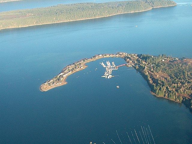
| Description | This is a photo I took December 27, 2005. It shows Deep Bay Harbour (Marina) surrounded by the Deep Bay Spit. The south tip of Hornby Island with Chrome Island Light off its end is above. The streaks in the bottom of the photo are an Oyster Farm. Deep Bay is on Vancouver Island and is part of British Columbia Canada. The photo is taken roughly East. The water off Deep Bay is Baynes Sound between Vancouver Island and Denman Island. Photo 2 of 2 |
| Date | |
| Source | Own work |
| Author | Ken Walker |
| Permission (Reusing this file) |
GFDL |
Licensing
edit
I, the copyright holder of this work, hereby publish it under the following licenses:

|
Permission is granted to copy, distribute and/or modify this document under the terms of the GNU Free Documentation License, Version 1.2 or any later version published by the Free Software Foundation; with no Invariant Sections, no Front-Cover Texts, and no Back-Cover Texts. A copy of the license is included in the section entitled GNU Free Documentation License. |
| This file is licensed under the Creative Commons Attribution-Share Alike 3.0 Unported license. | ||
| ||
| This licensing tag was added to this file as part of the GFDL licensing update. |
You may select the license of your choice.
| Camera location | | View this and other nearby images on: OpenStreetMap |
|---|
File history
Click on a date/time to view the file as it appeared at that time.
| Date/Time | Thumbnail | Dimensions | User | Comment | |
|---|---|---|---|---|---|
| current | 06:23, 24 July 2006 | | 1,600 × 1,200 (893 KB) | KenWalker (talk | contribs) | {{Information |Description=This is a photo I took December 27, 2005. It shows Deep Bay Harbour (Marina) surrounded by the Deep Bay Spit. The south tip of Hornby Island with Chrome Island Light off its end is above. The streaks in the bottom of the ph |
You cannot overwrite this file.
File usage on Commons
There are no pages that use this file.