File:Delahaye 1902 Tonneau on London to Brighton VCR 2009.jpg
Original file (3,872 × 2,592 pixels, file size: 4.12 MB, MIME type: image/jpeg)
Captions
Captions
Summary edit
| Description |
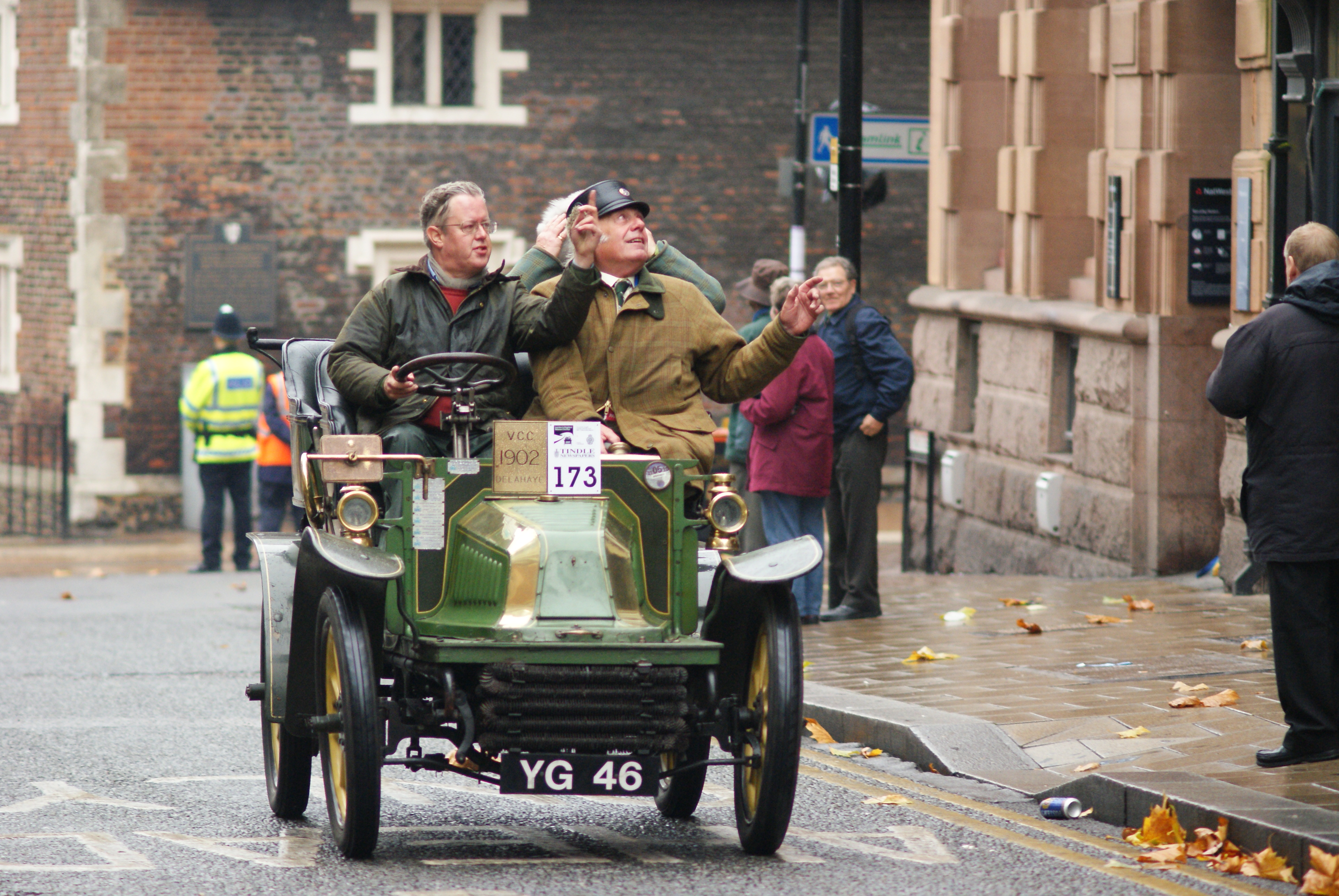
English: 1902 Delahaye tonneau
It's up There I presume that the team were looking up at the architecture, rather than debating where the drizzle was coming from. Car number 173 is a Delahaye, dating from 1902, entered by Tim Dickson. London Brighton Veteran Car Run 2009. The annual event takes place on the first Sunday of every November and commemorates the Emancipation Run of 14 November 1896 which celebrated the passing into law of the Locomotives on the Highway Act, which raised the speed limit for 'light locomotives' from 4 mph to 14 mph and abolished the requirement for these vehicles to be preceded by a man on foot. The law required the man on foot to carry a red flag but the requirement was actually abolished in 1878. However, the Locomotive Act was still widely known as the 'Red Flag Act' and a red flag was symbolically destroyed at the start of the Emancipation Run, by Lord Winchilsea. Over 30 pioneer motorists set off from London on the 1896 Run to endure the rough roads to the Sussex seaside resort but only 14 of the starters actually made the journey, and some evidence exists that one car was taken by rail and covered with mud before crossing the finishing line! The next run was staged in 1927 as a re-enactment of the 1896 Run and organised by the motoring editor of the Daily Sketch. The Run has taken place every November thereafter, with the exception of the war years and 1947 when petrol rationing was in force. From 1930 to the present day the event has been owned and professionally organised by The Royal Automobile Club. |
| Date | |
| Source | From geograph.org.uk |
| Author | Peter Trimming |
| Attribution (required by the license) | Peter Trimming / It's up There / |
| Camera location | | View this and other nearby images on: OpenStreetMap |
|---|
_heading:22.00&language=en)
| Object location | | View this and other nearby images on: OpenStreetMap |
|---|
_heading:22.00&language=en)
Licensing edit

|
This image was taken from the Geograph project collection. See this photograph's page on the Geograph website for the photographer's contact details. The copyright on this image is owned by Peter Trimming and is licensed for reuse under the Creative Commons Attribution-ShareAlike 2.0 license.
|
- You are free:
- to share – to copy, distribute and transmit the work
- to remix – to adapt the work
- Under the following conditions:
- attribution – You must give appropriate credit, provide a link to the license, and indicate if changes were made. You may do so in any reasonable manner, but not in any way that suggests the licensor endorses you or your use.
- share alike – If you remix, transform, or build upon the material, you must distribute your contributions under the same or compatible license as the original.
File history
Click on a date/time to view the file as it appeared at that time.
| Date/Time | Thumbnail | Dimensions | User | Comment | |
|---|---|---|---|---|---|
| current | 15:08, 9 September 2017 | | 3,872 × 2,592 (4.12 MB) | Geograph Update Bot (talk | contribs) | Higher-resolution version from Geograph. |
| 17:08, 3 March 2011 |  | 640 × 428 (84 KB) | GeographBot (talk | contribs) | == {{int:filedesc}} == {{Information |description={{en|1=It's up There I presume that the team were looking up at the architecture, rather than debating where the drizzle was coming from. Car number 173 is a Delahaye, dating from 1902, entered by Tim Dic |
You cannot overwrite this file.
File usage on Commons
The following page uses this file:
- File:It's up There - geograph.org.uk - 1566953.jpg (file redirect)
File usage on other wikis
The following other wikis use this file:
- Usage on de.wikipedia.org