File:Delian League Campaign Map.png
No higher resolution available.
Delian_League_Campaign_Map.png (500 × 500 pixels, file size: 526 KB, MIME type: image/png)
Captions
Captions
Add a one-line explanation of what this file represents
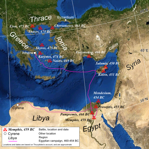
| Description | Map of the eastern Mediterranean, showing the location of battles fought by the Delian League, 477–450 BC |
| Date | (UTC) |
| Source | |
| Author |
|
| Other versions | Derivative works of this file: Mapa de campanya de la Lliga de Delos.jpg |
| This is a retouched picture, which means that it has been digitally altered from its original version. The original can be viewed here: Mediterranean Sea political map-blank.svg:
|
| This image is in the public domain because it is a screenshot from NASA’s globe software World Wind using a public domain layer, such as Blue Marble, MODIS, Landsat, SRTM, USGS or GLOBE.
|
 |
| This work was previously under Public Domain, or a Free License. It has been digitally enhanced and/or modified. This derivative work has been (or is hereby) released into the public domain by its author, [[:{{{1}}}:User:{{{3}}}|{{{3}}}]] at the [[:{{{1}}}:|{{{2}}}]] project. This applies worldwide. In some countries this is not legally possible; if so:
|
Original upload log
edit
This image is a derivative work of the following images:
- File:Mediterranean_Sea_political_map-blank.svg licensed with PD-WorldWind, PD-retouched-user-w
- 2008-05-19T16:14:51Z Sting 2046x1496 (1109412 Bytes) "Tropic of Cancer" label correction
- 2007-06-21T01:07:02Z Sting 2046x1496 (1109639 Bytes) {{Information |Description=Blank map of the [[:en:Mediterranean Sea|Mediterranean Sea]], with the State borders. |Source=Own work ;Background map : screenshot from NASA World Wind (Public Domain) |Date=June 2007 |Author=Eric
Uploaded with derivativeFX
File history
Click on a date/time to view the file as it appeared at that time.
| Date/Time | Thumbnail | Dimensions | User | Comment | |
|---|---|---|---|---|---|
| current | 20:39, 22 July 2009 | | 500 × 500 (526 KB) | MinisterForBadTimes (talk | contribs) | Some rearrangements |
| 20:30, 22 July 2009 |  | 500 × 500 (525 KB) | MinisterForBadTimes (talk | contribs) | Re-sized and shaped | |
| 06:56, 29 June 2009 |  | 1,000 × 731 (1.27 MB) | MinisterForBadTimes (talk | contribs) | {{Information |Description=Map of the eastern Mediterranean, showing the location of battles fought by the Delian League, 477–450 BC |Source=*File:Mediterranean_Sea_political_map-blank.svg |Date=2009-06-29 07:51 (UTC) |Author=*[[:File:Mediterr |
You cannot overwrite this file.
File usage on Commons
The following page uses this file:
File usage on other wikis
The following other wikis use this file:
- Usage on af.wikipedia.org
- Usage on azb.wikipedia.org
- Usage on ca.wikipedia.org
- Usage on el.wikipedia.org
- Usage on en.wikipedia.org
- Usage on es.wikipedia.org
- Usage on eu.wikipedia.org
- Usage on fa.wikipedia.org
- Usage on hr.wikipedia.org
- Usage on hu.wikipedia.org
- Usage on id.wikipedia.org
- Usage on it.wikipedia.org
- Usage on it.wikiversity.org
- Usage on pl.wikipedia.org
- Usage on pnb.wikipedia.org
- Usage on pt.wikipedia.org
- Usage on ru.wikipedia.org
- Usage on sh.wikipedia.org
- Usage on ta.wikipedia.org
- Usage on ur.wikipedia.org