File:Deltona Urbanized Urbanized Area Map.pdf

Size of this JPG preview of this PDF file: 776 × 600 pixels. Other resolutions: 311 × 240 pixels | 621 × 480 pixels | 994 × 768 pixels | 1,280 × 989 pixels | 1,650 × 1,275 pixels.
Original file (1,650 × 1,275 pixels, file size: 805 KB, MIME type: application/pdf)
Captions
Captions
Add a one-line explanation of what this file represents
Summary edit
| Description |
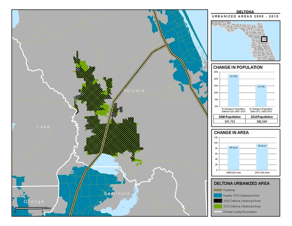
English: This map shows a 2010 Census defined urbanized area boundary and compares it to the 2000 boundary for the same area (showing population and area changes). The map was created by Domenico Pontoriero for the Florida Metropolitan Planning Organization Advisory Council using US Census data with research support from the Center for Urban Transportation Research. For more information, visit http://www.mpoac.org and http://cutr.usf.edu. |
| Date | |
| Source | Own work |
| Author | Domenico Pontoriero |
Licensing edit
I, the copyright holder of this work, hereby publish it under the following license:
This file is licensed under the Creative Commons Attribution-Share Alike 3.0 Unported license.
- You are free:
- to share – to copy, distribute and transmit the work
- to remix – to adapt the work
- Under the following conditions:
- attribution – You must give appropriate credit, provide a link to the license, and indicate if changes were made. You may do so in any reasonable manner, but not in any way that suggests the licensor endorses you or your use.
- share alike – If you remix, transform, or build upon the material, you must distribute your contributions under the same or compatible license as the original.
File history
Click on a date/time to view the file as it appeared at that time.
| Date/Time | Thumbnail | Dimensions | User | Comment | |
|---|---|---|---|---|---|
| current | 17:29, 15 November 2012 |  | 1,650 × 1,275 (805 KB) | DPontoriero (talk | contribs) | User created page with UploadWizard |
You cannot overwrite this file.
File usage on Commons
There are no pages that use this file.