File:Descending from the Tor - geograph.org.uk - 943373.jpg
Size of this preview: 450 × 600 pixels. Other resolutions: 180 × 240 pixels | 480 × 640 pixels.
Original file (480 × 640 pixels, file size: 93 KB, MIME type: image/jpeg)
Captions
Captions
Add a one-line explanation of what this file represents
Summary
edit
| Description |
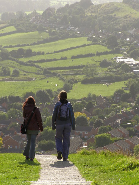
English: Descending from the Tor The least-steep descent from the summit of the Tor is along its western spine. The path has been concreted by the National Trust as part of their works to reduce the effects of visitor pressure on the fabric of the hill. The lack of steps on this route also means that, in principle, it could be suitable for wheelchairs if enough people were available to help push/pull.
In the distance are the southern slopes of Wearyall Hill, and houses along roads with logical names such as Tor View Avenue, Hill Head and The Roman Way. |
| Date | |
| Source | From geograph.org.uk |
| Author | Jim Champion |
| Attribution (required by the license) | Jim Champion / Descending from the Tor / |
| Camera location | | View this and other nearby images on: OpenStreetMap |
|---|
_heading:247.00&language=en)
| Object location | | View this and other nearby images on: OpenStreetMap |
|---|
_heading:247.00&language=en)
Licensing
edit

|
This image was taken from the Geograph project collection. See this photograph's page on the Geograph website for the photographer's contact details. The copyright on this image is owned by Jim Champion and is licensed for reuse under the Creative Commons Attribution-ShareAlike 2.0 license.
|
This file is licensed under the Creative Commons Attribution-Share Alike 2.0 Generic license.
Attribution: Jim Champion
- You are free:
- to share – to copy, distribute and transmit the work
- to remix – to adapt the work
- Under the following conditions:
- attribution – You must give appropriate credit, provide a link to the license, and indicate if changes were made. You may do so in any reasonable manner, but not in any way that suggests the licensor endorses you or your use.
- share alike – If you remix, transform, or build upon the material, you must distribute your contributions under the same or compatible license as the original.
File history
Click on a date/time to view the file as it appeared at that time.
| Date/Time | Thumbnail | Dimensions | User | Comment | |
|---|---|---|---|---|---|
| current | 09:39, 22 February 2011 | | 480 × 640 (93 KB) | GeographBot (talk | contribs) | == {{int:filedesc}} == {{Information |description={{en|1=Descending from the Tor The least-steep descent from the summit of the Tor is along its western spine. The path has been concreted by the National Trust as part of their works to reduce the effects |
You cannot overwrite this file.
File usage on Commons
There are no pages that use this file.