File:Descripsion des costs, pts., rades, illes de la Nouuele France faict selon son vray méridien - avec la déclinaison de la ment de plussieurs endrois selon que le sieur de Castes le franc le démontre en LOC 2006629903.jpg

Size of this preview: 800 × 562 pixels. Other resolutions: 320 × 225 pixels | 640 × 450 pixels | 1,024 × 720 pixels | 1,280 × 900 pixels | 2,560 × 1,799 pixels | 9,652 × 6,783 pixels.
Original file (9,652 × 6,783 pixels, file size: 8.12 MB, MIME type: image/jpeg)
Captions
Captions
Add a one-line explanation of what this file represents
Summary edit
| Description |
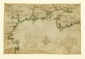
English: Shows coast of North America from western Nova Scotia to Cape Cod. Relief shown pictorially. Gift; Henry Harrisse; 1910. Pen-and-ink with green wash. Vellum chart collection, no. 15. LC Nautical charts on vellum, 15 Available also through the Library of Congress Web site as a raster image. Includes table of longitude calculations in upper right corner, title cartouche, and decorative scale not specifying measurement. Stamped on verso at lower left: 540. Imperfect: Vertically fold-lined at center; small holes at upper left and upper right. |
||
| Title | Descripsion des costs, pts., rades, illes de la Nouuele France faict selon son vray méridien : avec la déclinaison de la ment de plussieurs endrois selon que le sieur de Castes le franc le démontre en son liure de la mécométrie de l'emnt. | ||
| Shelf ID | G3321.P5 1607 .C4 | ||
| Date | |||
| Source | https://www.loc.gov/item/2006629903/ | ||
| Author | Champlain, Samuel De | ||
| Permission (Reusing this file) |
|
||
| Other versions |
|
||
| Location | Atlantic Coast · North America | ||
| Part of | American Memory · Catalog · Geography And Map Division · Discovery And Exploration | ||
| Subject | Maps, Manuscript · Atlantic Coast (North America) · Nautical Charts · North America · Early Works To 1800 · Atlantic Coast |

Licensing edit
|
This is a faithful photographic reproduction of a two-dimensional, public domain work of art. The work of art itself is in the public domain for the following reason:
The official position taken by the Wikimedia Foundation is that "faithful reproductions of two-dimensional public domain works of art are public domain".
This photographic reproduction is therefore also considered to be in the public domain in the United States. In other jurisdictions, re-use of this content may be restricted; see Reuse of PD-Art photographs for details. | ||||
File history
Click on a date/time to view the file as it appeared at that time.
| Date/Time | Thumbnail | Dimensions | User | Comment | |
|---|---|---|---|---|---|
| current | 10:01, 1 June 2018 | | 9,652 × 6,783 (8.12 MB) | Fæ (talk | contribs) | LOC Maps https://www.loc.gov/item/2006629903/ #16905 |
You cannot overwrite this file.
File usage on Commons
The following page uses this file: