File:Detail of Pier No. 2, with Span No. 1 at left and Span No. 2 at right, view to southwest - Gillespie Dam Bridge, Spanning Gila River on Old US 80 Highway, south of Gillespie Dam, HAER AZ-69-18.tif
Size of this JPG preview of this TIF file: 481 × 599 pixels. Other resolutions: 192 × 240 pixels | 385 × 480 pixels | 616 × 768 pixels | 822 × 1,024 pixels | 1,643 × 2,048 pixels | 4,315 × 5,378 pixels.
Original file (4,315 × 5,378 pixels, file size: 22.13 MB, MIME type: image/tiff)
Captions
Captions
Add a one-line explanation of what this file represents
Summary edit
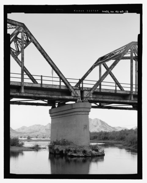
| Detail of Pier No. 2, with Span No. 1 at left and Span No. 2 at right, view to southwest - Gillespie Dam Bridge, Spanning Gila River on Old US 80 Highway, south of Gillespie Dam, Arlington, Maricopa County, AZ | ||||
|---|---|---|---|---|
| Photographer |
Fraser, Clayton B. Fraserdesign. Related names:
|
|||
| Title |
Detail of Pier No. 2, with Span No. 1 at left and Span No. 2 at right, view to southwest - Gillespie Dam Bridge, Spanning Gila River on Old US 80 Highway, south of Gillespie Dam, Arlington, Maricopa County, AZ |
|||
| Depicted place | Arizona; Maricopa County; Arlington | |||
| Date | 2006 | |||
| Dimensions | 4 x 5 in. | |||
| Current location |
Library of Congress Prints and Photographs Division Washington, D.C. 20540 USA http://hdl.loc.gov/loc.pnp/pp.print |
|||
| Accession number |
HAER AZ-69-18 |
|||
| Credit line |
|
|||
| Notes |
|
|||
| Source | https://www.loc.gov/pictures/item/az0577.photos.363880p | |||
| Permission (Reusing this file) |
|
|||

| Object location | | View this and other nearby images on: OpenStreetMap |
|---|
File history
Click on a date/time to view the file as it appeared at that time.
| Date/Time | Thumbnail | Dimensions | User | Comment | |
|---|---|---|---|---|---|
| current | 00:26, 2 July 2014 |  | 4,315 × 5,378 (22.13 MB) | Fæ (talk | contribs) | GWToolset: Creating mediafile for Fæ. HABS 1 July 2014 (201:300) |
You cannot overwrite this file.
File usage on Commons
The following page uses this file: