File:Detail of cornice on west elevation - Providence and Worcester Railroad, Freight House, Canal Street, Providence, Providence County, RI HAER RI,4-PROV,176A-18.tif

Size of this JPG preview of this TIF file: 746 × 600 pixels. Other resolutions: 299 × 240 pixels | 597 × 480 pixels | 955 × 768 pixels | 1,274 × 1,024 pixels | 2,547 × 2,048 pixels | 4,852 × 3,901 pixels.
Original file (4,852 × 3,901 pixels, file size: 18.05 MB, MIME type: image/tiff)
Captions
Captions
Add a one-line explanation of what this file represents
Summary edit
| Detail of cornice on west elevation - Providence and Worcester Railroad, Freight House, Canal Street, Providence, Providence County, RI | ||||
|---|---|---|---|---|
| Title |
Detail of cornice on west elevation - Providence and Worcester Railroad, Freight House, Canal Street, Providence, Providence County, RI |
|||
| Description |
Tefft, Thomas A; Providence and Worcester Railroad; Penn Central Railroad; New York, New Haven, and Hartford Railroad; Clement, Daniel E, historian; Renchaw, Clifford B, historian; Harrington, Richard B, historian; deBoer, Cornelis J, delineator |
|||
| Depicted place | Rhode Island; Providence County; Providence | |||
| Date | Documentation compiled after 1968 | |||
| Dimensions | 4 x 5 in. | |||
| Current location |
Library of Congress Prints and Photographs Division Washington, D.C. 20540 USA http://hdl.loc.gov/loc.pnp/pp.print |
|||
| Accession number |
HAER RI,4-PROV,176A-18 |
|||
| Credit line |
|
|||
| Notes |
|
|||
| Source | https://www.loc.gov/pictures/item/ri0345.photos.145732p | |||
| Permission (Reusing this file) |
|
|||

| Object location | | View this and other nearby images on: OpenStreetMap |
|---|
File history
Click on a date/time to view the file as it appeared at that time.
| Date/Time | Thumbnail | Dimensions | User | Comment | |
|---|---|---|---|---|---|
| current | 21:42, 1 August 2014 | 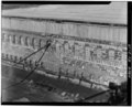 | 4,852 × 3,901 (18.05 MB) | Fæ (talk | contribs) | GWToolset: Creating mediafile for Fæ. HABS 31 July 2014 (3000:3200) |
You cannot overwrite this file.
File usage on Commons
The following page uses this file: