File:Detail showing bracing under deck of bridge - Station Road Bridge, Spanning Cuyahoga River, Brecksville, Cuyahoga County, OH HAER OHIO,18-BRECK,4-10.tif

Size of this JPG preview of this TIF file: 800 × 573 pixels. Other resolutions: 320 × 229 pixels | 640 × 458 pixels | 1,024 × 733 pixels | 1,280 × 917 pixels | 2,560 × 1,833 pixels | 5,000 × 3,581 pixels.
Original file (5,000 × 3,581 pixels, file size: 17.08 MB, MIME type: image/tiff)
Captions
Captions
Add a one-line explanation of what this file represents
Summary edit
| Detail showing bracing under deck of bridge - Station Road Bridge, Spanning Cuyahoga River, Brecksville, Cuyahoga County, OH | ||||
|---|---|---|---|---|
| Title |
Detail showing bracing under deck of bridge - Station Road Bridge, Spanning Cuyahoga River, Brecksville, Cuyahoga County, OH |
|||
| Depicted place | Ohio; Cuyahoga County; Brecksville | |||
| Date | Documentation compiled after 1968 | |||
| Dimensions | 5 x 7 in. | |||
| Current location |
Library of Congress Prints and Photographs Division Washington, D.C. 20540 USA http://hdl.loc.gov/loc.pnp/pp.print |
|||
| Accession number |
HAER OHIO,18-BRECK,4-10 |
|||
| Credit line |
|
|||
| Notes |
|
|||
| Source | https://www.loc.gov/pictures/item/oh1538.photos.125394p | |||
| Permission (Reusing this file) |
|
|||

| Object location | | View this and other nearby images on: OpenStreetMap |
|---|
File history
Click on a date/time to view the file as it appeared at that time.
| Date/Time | Thumbnail | Dimensions | User | Comment | |
|---|---|---|---|---|---|
| current | 14:47, 30 July 2014 | 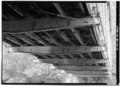 | 5,000 × 3,581 (17.08 MB) | Fæ (talk | contribs) | GWToolset: Creating mediafile for Fæ. HABS 30 July 2014 (2601:2900) |
You cannot overwrite this file.
File usage on Commons
The following page uses this file: