File:Deutschland-Karte.jpg

Original file (1,500 × 2,083 pixels, file size: 3.67 MB, MIME type: image/jpeg)
Captions
Captions
Summary
edit
| Description |
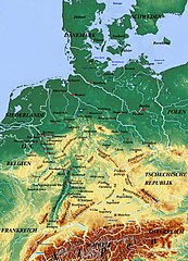
Deutsch: Liste der Berge auf der Karte : Alpen, Bayerische Alpen, Bayerischer Wald, Böhmerwald, Eifel, Erzgebirge, Fichtelgebirge, Frankenwald, Harz, Hunsrück, Jura, Oberpfälzer Wald, Rhön, Rothaargebirge, Schwäbische Alb, Schwarzwald, Taunus, Thüringer Wald, Vogelsberg, Vogesen, Westerwald.
|
| Date | |
| Source | physicalmap.org |
| Author | physicalmap.org |
Licensing
edit
- You are free:
- to share – to copy, distribute and transmit the work
- to remix – to adapt the work
- Under the following conditions:
- attribution – You must give appropriate credit, provide a link to the license, and indicate if changes were made. You may do so in any reasonable manner, but not in any way that suggests the licensor endorses you or your use.
- share alike – If you remix, transform, or build upon the material, you must distribute your contributions under the same or compatible license as the original.
File history
Click on a date/time to view the file as it appeared at that time.
| Date/Time | Thumbnail | Dimensions | User | Comment | |
|---|---|---|---|---|---|
| current | 21:46, 16 June 2022 | | 1,500 × 2,083 (3.67 MB) | Maps world (talk | contribs) | modify image |
| 17:06, 3 June 2022 |  | 1,500 × 2,083 (3.84 MB) | Maps world (talk | contribs) | modify image | |
| 15:06, 14 May 2022 |  | 1,500 × 2,083 (3.79 MB) | Maps world (talk | contribs) | modify image | |
| 22:52, 29 January 2022 |  | 1,500 × 2,083 (3.75 MB) | Maps world (talk | contribs) | modify image | |
| 20:37, 29 December 2020 |  | 1,500 × 2,083 (3.75 MB) | Maps world (talk | contribs) | modify information | |
| 20:19, 29 December 2020 |  | 1,500 × 2,083 (3.75 MB) | Maps world (talk | contribs) | modify information | |
| 17:40, 12 December 2020 |  | 1,500 × 2,083 (3.75 MB) | Maps world (talk | contribs) | modify information | |
| 15:45, 1 December 2020 |  | 1,500 × 2,083 (3.81 MB) | Maps world (talk | contribs) | modify information | |
| 12:40, 11 August 2020 |  | 1,500 × 2,083 (4.02 MB) | Maps world (talk | contribs) | Neue Informationen hinzufügen. | |
| 11:47, 2 July 2020 |  | 1,500 × 2,083 (3.86 MB) | Maps world (talk | contribs) | Verbesserung der Kartenzusammensetzung |
You cannot overwrite this file.
File usage on Commons
There are no pages that use this file.
File usage on other wikis
The following other wikis use this file:
- Usage on de.wikipedia.org