File:Deutschland Lage von Württemberg-Baden.svg

Size of this PNG preview of this SVG file: 506 × 599 pixels. Other resolutions: 203 × 240 pixels | 405 × 480 pixels | 648 × 768 pixels | 865 × 1,024 pixels | 1,729 × 2,048 pixels | 1,075 × 1,273 pixels.
Original file (SVG file, nominally 1,075 × 1,273 pixels, file size: 498 KB)
Captions
Captions
Add a one-line explanation of what this file represents
Summary edit
| Description |
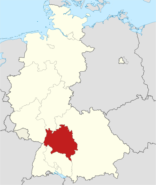
Deutsch: Positionskarte von Deutschland Quadratische Plattkarte, N-S-Streckung 150 %. Land Württemberg-Baden rot eingefärbt. Geographische Begrenzung der Karte: * N: 55.1° N * S: 47.2° N * W: 5.5° O * O: 15.5° O English: Location map of Germany Equirectangular projection, N/S stretching 150 %. Geographic limits of the map: * N: 55.1° N * S: 47.2° N * W: 5.5° E * E: 15.5° E |
||
| Date | |||
| Source | Own work based on: Germany location map.svg by NordNordWest | ||
| Author | Marco Kaiser | ||
| Other versions |
|
||
| SVG development | This locator map was created with Adobe Illustrator by NordNordWest, and with Inkscape.
|
Licensing edit
I, the copyright holder of this work, hereby publish it under the following licenses:
This file is licensed under the Creative Commons Attribution-Share Alike 3.0 Unported license.
- You are free:
- to share – to copy, distribute and transmit the work
- to remix – to adapt the work
- Under the following conditions:
- attribution – You must give appropriate credit, provide a link to the license, and indicate if changes were made. You may do so in any reasonable manner, but not in any way that suggests the licensor endorses you or your use.
- share alike – If you remix, transform, or build upon the material, you must distribute your contributions under the same or compatible license as the original.

|
Permission is granted to copy, distribute and/or modify this document under the terms of the GNU Free Documentation License, Version 1.2 or any later version published by the Free Software Foundation; with no Invariant Sections, no Front-Cover Texts, and no Back-Cover Texts. A copy of the license is included in the section entitled GNU Free Documentation License. |
You may select the license of your choice.
Original upload log edit
This image is a derivative work of the following images:
- Germany location map.svg licensed with Cc-by-sa-3.0, GFDL
- 2008-10-13T14:36:44Z NordNordWest 1075x1273 (620685 Bytes)
- 2008-10-09T21:13:47Z NordNordWest 1075x1273 (627868 Bytes) smaller file, data optimized
- 2008-06-30T20:25:05Z NordNordWest 1076x1274 (899543 Bytes) {{Information |Description= {{de|Positionskarte von [[:de:Deutschland|Deutschland]]}} Quadratische Plattkarte, N-S-Streckung 150 %. Geographische Begrenzung der Karte: * N: 55.1° N * S: 47.2° N * W: 5.5° O * O: 15.5° O {{
- Germany, Federal Republic of location map December 1950 - April 1952.svg licensed with Cc-by-sa-3.0, GFDL
Uploaded with derivativeFX
File history
Click on a date/time to view the file as it appeared at that time.
| Date/Time | Thumbnail | Dimensions | User | Comment | |
|---|---|---|---|---|---|
| current | 10:02, 10 June 2009 | | 1,075 × 1,273 (498 KB) | Marco Kaiser (talk | contribs) | {{Information |Description={{de|Positionskarte von Deutschland}} Quadratische Plattkarte, N-S-Streckung 150 %. Geographische Begrenzung der Karte: * N: 55.1° N * S: 47.2° N * W: 5.5° O * O: 15.5° O {{en|Location map of [[:en:German |
You cannot overwrite this file.
File usage on Commons
The following page uses this file:
File usage on other wikis
The following other wikis use this file:
- Usage on af.wikipedia.org
- Usage on als.wikipedia.org
- Usage on ar.wikipedia.org
- Usage on ast.wikipedia.org
- Usage on ca.wikipedia.org
- Usage on de.wikipedia.org
- Usage on en.wikipedia.org
- Usage on fi.wikipedia.org
- Usage on he.wikipedia.org
- Usage on it.wikipedia.org
- Usage on pl.wikipedia.org
- Usage on ru.wikipedia.org
- Usage on www.wikidata.org