File:Deutschland Metropolregionen.png

Size of this preview: 450 × 599 pixels. Other resolutions: 180 × 240 pixels | 360 × 480 pixels | 576 × 768 pixels | 769 × 1,024 pixels | 2,000 × 2,664 pixels.
Original file (2,000 × 2,664 pixels, file size: 1.74 MB, MIME type: image/png)
Captions
Captions
Add a one-line explanation of what this file represents

|
This file has been superseded by Karte Metropolregionen.svg. It is recommended to use the other file. Please note that deleting superseded images requires consent.
|

|
Summary edit
| Description |
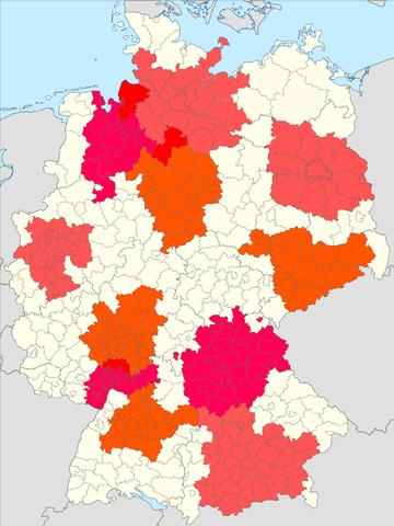
Karte der Metropolregionen in Deutschland:
|
||||||||
| Date | 08.05.2006 | ||||||||
| Source | Own Work based on GFDL Image Image:Germany Laender Map.png | ||||||||
| Author | de:User:Geo-Loge | ||||||||
| Permission (Reusing this file) |
|

File history
Click on a date/time to view the file as it appeared at that time.
| Date/Time | Thumbnail | Dimensions | User | Comment | |
|---|---|---|---|---|---|
| current | 19:40, 23 October 2013 | | 2,000 × 2,664 (1.74 MB) | ThomasPusch (talk | contribs) | Nur ein Detail: der Bodensee war bis jetzt als Landfläche dargestellt, jetzt ist er eine Wasserfläche... |
| 19:11, 23 October 2013 |  | 2,000 × 2,664 (1.74 MB) | ThomasPusch (talk | contribs) | Berücksichtigung der neuen Kreisgrenzen in Mecklenburg-Vorpommern nach der Verwaltungsreform von September 2011, Berichtigung des Gebiets der Region Hamburg nach der Änderung von Mai 2012, Aufnahme des bislang vergessenen Landkreises Osnabrück in di... | |
| 16:22, 7 January 2010 |  | 1,503 × 2,002 (775 KB) | Crissov (talk | contribs) | based on Firefox rendering of file:Deutschland_Metropolregionen.svg | |
| 23:02, 27 August 2006 |  | 668 × 910 (27 KB) | David Liuzzo (talk | contribs) | == Beschreibung == {{Information| |Description= Karte der Metropolregionen in Deutschland: *#Berlin/Brandenburg *#Bremen/Oldenburg *#Frankfurt/Rhein-Main *#Hamburg *#Hannover *#München *#Nürnberg *#Rhein-Neckar-Dreieck *#Rhein-Ruhr *#Sachsendreieck *#S |
You cannot overwrite this file.
File usage on Commons
The following page uses this file:
File usage on other wikis
The following other wikis use this file: