File:Devastating floods in Brazil.jpg

Original file (4,516 × 2,540 pixels, file size: 3.8 MB, MIME type: image/jpeg)
Captions
Captions
Summary
edit
| Description |
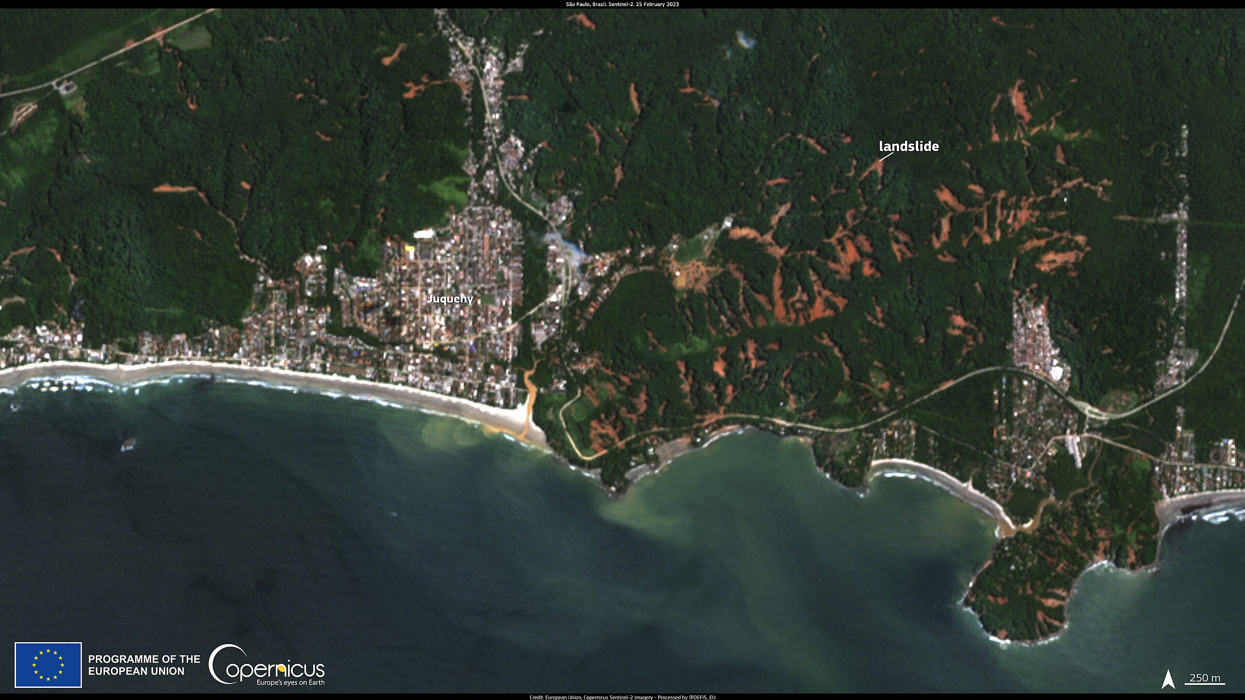
English: On 19 February 2023, disastrous floods hit the state of São Paulo in Brazil, causing widespread damage and claiming the lives of 57 people. The heavy rains triggered landslides and flooding in coastal towns of the country’s richest state, causing extensive damage to housing and infrastructure. More than 4,000 people were forced to evacuate their homes, and dozens are still missing while search and rescue efforts are ongoing. This image, acquired by one of the Copernicus Sentinel-2 satellites on 25 February, shows the area surrounding Juquehy, a popular beach in the city of São Sebastião, which was particularly affected by the floods. In the image, the landslides caused by the heavy rains appear in brown colours, in contrast with the green vegetation, and the sediments from the increased river discharge into the sea are also visible. The Copernicus Sentinel satellites provide valuable data to identify and delineate the extent of affected areas when a flood occurs and to monitor the consequences of such disastrous events. |
| Date | 28 February 2023 (upload date) |
| Source | Devastating floods in Brazil |
| Author | European Union , Copernicus Sentinel-2 imagery |
Licensing
edit

|
This image contains data from a satellite in the Copernicus Programme, such as Sentinel-1, Sentinel-2 or Sentinel-3. Attribution is required when using this image.
Attribution: Contains modified Copernicus Sentinel data 2023
The use of Copernicus Sentinel Data is regulated under EU law (Commission Delegated Regulation (EU) No 1159/2013 and Regulation (EU) No 377/2014). Relevant excerpts:
Free access shall be given to GMES dedicated data [...] made available through GMES dissemination platforms [...].
Access to GMES dedicated data [...] shall be given for the purpose of the following use in so far as it is lawful:
GMES dedicated data [...] may be used worldwide without limitations in time.
GMES dedicated data and GMES service information are provided to users without any express or implied warranty, including as regards quality and suitability for any purpose. |
File history
Click on a date/time to view the file as it appeared at that time.
| Date/Time | Thumbnail | Dimensions | User | Comment | |
|---|---|---|---|---|---|
| current | 12:12, 1 August 2023 | | 4,516 × 2,540 (3.8 MB) | OptimusPrimeBot (talk | contribs) | #Spacemedia - Upload of https://www.copernicus.eu/system/files/2023-02/image_day/20230228_LandslidesBrazil.jpg via Commons:Spacemedia |
You cannot overwrite this file.
File usage on Commons
There are no pages that use this file.