File:Devil's Bridge Worm's Head - geograph.org.uk - 334016.jpg

Size of this preview: 468 × 599 pixels. Other resolutions: 187 × 240 pixels | 500 × 640 pixels.
Original file (500 × 640 pixels, file size: 104 KB, MIME type: image/jpeg)
Captions
Captions
Add a one-line explanation of what this file represents
Summary edit
| Description |
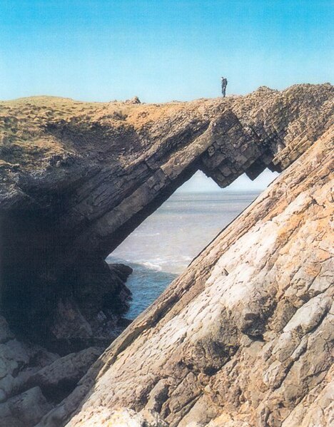
English: Devil's Bridge Worms Head At the Devil's Bridge, the steeply dipping carboniferous limestone has been eroded by wave action into this spectacular natural arch which is very photogenic! |
| Date | |
| Source | From geograph.org.uk |
| Author | Gordon Hatton |
| Attribution (required by the license) | Gordon Hatton / Devil's Bridge Worms Head / |
| Object location | | View this and other nearby images on: OpenStreetMap |
|---|
_heading:315.00&language=en)
Licensing edit

|
This image was taken from the Geograph project collection. See this photograph's page on the Geograph website for the photographer's contact details. The copyright on this image is owned by Gordon Hatton and is licensed for reuse under the Creative Commons Attribution-ShareAlike 2.0 license.
|
This file is licensed under the Creative Commons Attribution-Share Alike 2.0 Generic license.
Attribution: Gordon Hatton
- You are free:
- to share – to copy, distribute and transmit the work
- to remix – to adapt the work
- Under the following conditions:
- attribution – You must give appropriate credit, provide a link to the license, and indicate if changes were made. You may do so in any reasonable manner, but not in any way that suggests the licensor endorses you or your use.
- share alike – If you remix, transform, or build upon the material, you must distribute your contributions under the same or compatible license as the original.
File history
Click on a date/time to view the file as it appeared at that time.
| Date/Time | Thumbnail | Dimensions | User | Comment | |
|---|---|---|---|---|---|
| current | 21:35, 30 December 2010 | | 500 × 640 (104 KB) | GeographBot (talk | contribs) | == {{int:filedesc}} == {{Information |description={{en|1=Devil's Bridge Worms Head At the Devil's Bridge, the steeply dipping carboniferous limestone has been eroded by wave action into this spectacular natural arch which is very photogenic!}} |date=2004- |
You cannot overwrite this file.
File usage on Commons
The following 2 pages use this file: