File:Die Zee Custe van tLand van Poictou ende Bordeaux tuschen Picqueliers ende de Riviere van Bordeaux alsoe hem tlant aldaer vuijt der zee opdoet ende verthoont - btv1b53156768t (2 of 3).jpg

Original file (8,468 × 6,418 pixels, file size: 8.71 MB, MIME type: image/jpeg)
Captions
Captions
Summary
edit| Warning | The original file is very high-resolution. It might not load properly or could cause your browser to freeze when opened at full size. |
|---|
| Author |
Waghenaer, Lucas Janszoon (1533?-1606). Cartographe |
||||||||||||||||||||||||||
| Title |
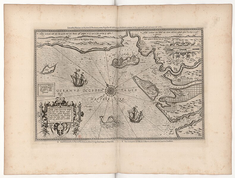
Die Zee Custe van tLand van Poictou ende Bordeaux tuschen Picqueliers ende de Riviere van Bordeaux alsoe hem tlant aldaer vuijt der zee opdoet ende verthoont
Alternative title: Les costes Marines de Poictou & Bordeaux, entre Piquelier & la Riviere de Bordeaux, comme le Païs apparoist, aulx arrivants de la Mer |
||||||||||||||||||||||||||
| Description |
Français : Sujet : Cartouches (ornement)
Poitou, Province du -- Côtes Saintonge, Province de -- Côtes Gironde, Estuaire de la Échelle(s) : [Ca 1:374 000], Germanica, Duytsche mijlen 15 in graet, 5 [= 9,9 cm] Appartient à l’ensemble documentaire : PoitouCh1 Couverture : France – Nouvelle-Aquitaine – Charente-Maritime France – Pays-de-la-Loire – Vendée France – Nouvelle-Aquitaine – Gironde Langue : français néerlandais latin Éditeur : [s.n.] |
||||||||||||||||||||||||||
| Date | 1590 | ||||||||||||||||||||||||||
| Dimensions | height: 52 cm (20.4 in); width: 35.5 cm (13.9 in) | ||||||||||||||||||||||||||
| Collection |
|
||||||||||||||||||||||||||
| References |
Français : Notice de recueil : http://catalogue.bnf.fr/ark:/12148/cb45256873d
Appartient à : [Volume XI de la collection Gaston d'Orléans contenant la description du royaume de France, partie III] ; 46-47 Notice du catalogue : http://catalogue.bnf.fr/ark:/12148/cb45272309c Extrait de Pars Prima Du Miroir De La Navigation, ... ; Spiegel der Zeevaerdt / door Lucas Jansz Waghenaer, . |
||||||||||||||||||||||||||
| Source/Photographer |
Français : Bibliothèque nationale de France, département Cartes et plans, GE BB-246 (XI, 46-47)
Bibliothèque nationale de France (2/3) |
||||||||||||||||||||||||||
| Permission (Reusing this file) |
|
||||||||||||||||||||||||||

.jpg&action=edit§ion=1)
.jpg&flash=no)
File history
Click on a date/time to view the file as it appeared at that time.
| Date/Time | Thumbnail | Dimensions | User | Comment | |
|---|---|---|---|---|---|
| current | 13:53, 21 July 2022 | | 8,468 × 6,418 (8.71 MB) | Gzen92Bot (talk | contribs) | Gallica btv1b53156768t |
You cannot overwrite this file.
File usage on Commons
The following page uses this file:
.jpg)
.jpg&oldid=825772954)