File:DiefflenKarteS28C-6e15110415000.jpg

Size of this preview: 419 × 599 pixels. Other resolutions: 168 × 240 pixels | 336 × 480 pixels | 537 × 768 pixels | 716 × 1,024 pixels | 1,772 × 2,534 pixels.
Original file (1,772 × 2,534 pixels, file size: 1,012 KB, MIME type: image/jpeg)
Captions
Captions
Add a one-line explanation of what this file represents
Summary edit
| Description |
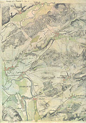
Deutsch: Diefflen, Kartenaufnahme der Rheinlande durchTranchot und v. Müffling 1803-1820, 255 Saarlouis, Publikationen der Gesellschaft für Rheinische Geschichtskunde, XII, 2. Abteilung, Neue Folge, hrsg. vom Landesvermessungsamt des Saarlandes 1969, aufgenommen im Jahr 1818 von Leutnant Cornely und Leutnant Reiche, Maßstab 1 : 25.000, 4 cm auf der Karte entsprechen 1 km in der Natur |
| Date | |
| Source | Own work |
| Author | Oktobersonne |
Licensing edit
I, the copyright holder of this work, hereby publish it under the following license:
This file is licensed under the Creative Commons Attribution-Share Alike 4.0 International license.
- You are free:
- to share – to copy, distribute and transmit the work
- to remix – to adapt the work
- Under the following conditions:
- attribution – You must give appropriate credit, provide a link to the license, and indicate if changes were made. You may do so in any reasonable manner, but not in any way that suggests the licensor endorses you or your use.
- share alike – If you remix, transform, or build upon the material, you must distribute your contributions under the same or compatible license as the original.
File history
Click on a date/time to view the file as it appeared at that time.
| Date/Time | Thumbnail | Dimensions | User | Comment | |
|---|---|---|---|---|---|
| current | 16:37, 5 November 2015 | | 1,772 × 2,534 (1,012 KB) | Oktobersonne (talk | contribs) | User created page with UploadWizard |
You cannot overwrite this file.
File usage on Commons
There are no pages that use this file.
File usage on other wikis
The following other wikis use this file:
- Usage on de.wikipedia.org