File:Districts of Allstedt.svg

Size of this PNG preview of this SVG file: 357 × 599 pixels. Other resolutions: 143 × 240 pixels | 286 × 480 pixels | 457 × 768 pixels | 610 × 1,024 pixels | 1,220 × 2,048 pixels | 435 × 730 pixels.
Original file (SVG file, nominally 435 × 730 pixels, file size: 174 KB)
Captions
Captions
Add a one-line explanation of what this file represents
Summary edit
| Description |
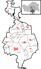
Deutsch: Übersichtskarte mit den Ortschaften in der Stadt Allstedt im Landkreis Mansfeld-Südharz in Sachsen-Anhalt, Deutschland.
English: Location of the districts of the municipality Allstedt in Mansfeld-Südharz in Saxony-Anhalt, Germany.
This SVG file was uploaded with Commonist. |
||
| Date | |||
| Source | Own work, with informations from LGB DE-ST and the work of Hagar66 | ||
| Author | Pomfuttge | ||
| SVG development |
Licensing edit
I, the copyright holder of this work, hereby publish it under the following licenses:

|
Permission is granted to copy, distribute and/or modify this document under the terms of the GNU Free Documentation License, Version 1.2 or any later version published by the Free Software Foundation; with no Invariant Sections, no Front-Cover Texts, and no Back-Cover Texts. A copy of the license is included in the section entitled GNU Free Documentation License. |
This file is licensed under the Creative Commons Attribution-Share Alike 3.0 Unported, 2.5 Generic, 2.0 Generic and 1.0 Generic license.
- You are free:
- to share – to copy, distribute and transmit the work
- to remix – to adapt the work
- Under the following conditions:
- attribution – You must give appropriate credit, provide a link to the license, and indicate if changes were made. You may do so in any reasonable manner, but not in any way that suggests the licensor endorses you or your use.
- share alike – If you remix, transform, or build upon the material, you must distribute your contributions under the same or compatible license as the original.
You may select the license of your choice.
File history
Click on a date/time to view the file as it appeared at that time.
| Date/Time | Thumbnail | Dimensions | User | Comment | |
|---|---|---|---|---|---|
| current | 22:04, 22 December 2010 | | 435 × 730 (174 KB) | Pomfuttge (talk | contribs) | colour |
| 21:52, 22 December 2010 |  | 435 × 730 (173 KB) | Pomfuttge (talk | contribs) | +villages | |
| 11:17, 26 September 2010 |  | 435 × 730 (107 KB) | Pomfuttge (talk | contribs) | colour | |
| 10:48, 11 September 2010 |  | 435 × 730 (105 KB) | Pomfuttge (talk | contribs) | == {{int:filedesc}} == {{Information |Description= {{de|Lagekarte der Ortschaften der Gemeide Allstedt}} {{en|Location of the districts of the german municipality Allstedt}} |Source={{own}} |Date=2010-09-11 |Author=[[User |
You cannot overwrite this file.
File usage on Commons
The following 12 pages use this file:
- File:Beyernaumburg in Allstedt.svg
- File:Emseloh in Allstedt.svg
- File:Holdenstedt in Allstedt.svg
- File:Katharinenrieth in Allstedt.svg
- File:Liedersdorf in Allstedt.svg
- File:Mittelhausen in Allstedt.svg
- File:Niederröblingen in Allstedt.svg
- File:Nienstedt in Allstedt.svg
- File:Pölsfeld in Allstedt.svg
- File:Sotterhausen in Allstedt.svg
- File:Winkel in Allstedt.svg
- File:Wolferstedt in Allstedt.svg
File usage on other wikis
The following other wikis use this file:
- Usage on de.wikipedia.org