File:Domaine ducal de Bretagne sous le règne de Jean V-fr.svg

Size of this PNG preview of this SVG file: 689 × 600 pixels. Other resolutions: 276 × 240 pixels | 551 × 480 pixels | 882 × 768 pixels | 1,176 × 1,024 pixels | 2,353 × 2,048 pixels | 1,668 × 1,452 pixels.
Original file (SVG file, nominally 1,668 × 1,452 pixels, file size: 236 KB)
Captions
Captions
Add a one-line explanation of what this file represents
Summary
edit| Description |
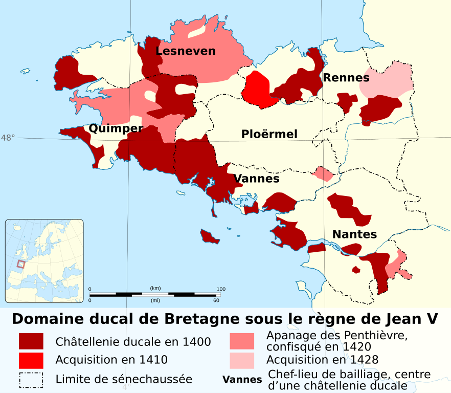
English: Evolution map of the ducal domain of Brittany under John VI of Brittany between 1400 and 1428. Français : Carte de l'évolution du domaine ducal de Bretagne sous le règne de Jean V de Bretagne entre 1400 et 1428. |
||
| Date | |||
| Source |
|
||
| Author | Sémhur (talk) | ||
| Permission (Reusing this file) |
|||
| Attribution (required by the license) | © Sémhur / Wikimedia Commons / | ||
| SVG | W3C-validity not checked.
|
||
| Graphic Lab | |||
| Other versions |


| Object location | | View this and other nearby images on: OpenStreetMap |
|---|
Licensing
edit
I, the copyright holder of this work, hereby publish it under the following licenses:
| Copyleft: This work of art is free; you can redistribute it and/or modify it according to terms of the Free Art License. You will find a specimen of this license on the Copyleft Attitude site as well as on other sites. |
This file is licensed under the Creative Commons Attribution-Share Alike Attribution-Share Alike 4.0 International, 3.0 Unported, 2.5 Generic, 2.0 Generic and 1.0 Generic license.
- You are free:
- to share – to copy, distribute and transmit the work
- to remix – to adapt the work
- Under the following conditions:
- attribution – You must give appropriate credit, provide a link to the license, and indicate if changes were made. You may do so in any reasonable manner, but not in any way that suggests the licensor endorses you or your use.
- share alike – If you remix, transform, or build upon the material, you must distribute your contributions under the same or compatible license as the original.
You may select the license of your choice.
File history
Click on a date/time to view the file as it appeared at that time.
| Date/Time | Thumbnail | Dimensions | User | Comment | |
|---|---|---|---|---|---|
| current | 18:07, 17 August 2014 | | 1,668 × 1,452 (236 KB) | Sémhur (talk | contribs) | Jean 5, pas Jean 4 ! |
| 10:00, 16 August 2014 |  | 1,668 × 1,452 (236 KB) | Sémhur (talk | contribs) | ||
| 09:59, 16 August 2014 |  | 556 × 484 (236 KB) | Sémhur (talk | contribs) | == {{int:filedesc}} == {{Information |Description={{Multilingual description |en= Evolution map of the ducal domain of Brittany under John V of Brittany between 1400 and 1428. |fr= Carte de l'évolution du domaine ducal... |
You cannot overwrite this file.
File usage on Commons
The following 2 pages use this file:
File usage on other wikis
The following other wikis use this file:
- Usage on ca.wikipedia.org
- Usage on fr.wikipedia.org
- Usage on ru.wikipedia.org