File:Donington circuit.svg

Size of this PNG preview of this SVG file: 600 × 600 pixels. Other resolutions: 240 × 240 pixels | 480 × 480 pixels | 768 × 768 pixels | 1,024 × 1,024 pixels | 2,048 × 2,048 pixels | 1,500 × 1,500 pixels.
Original file (SVG file, nominally 1,500 × 1,500 pixels, file size: 281 KB)
Captions
Captions
Add a one-line explanation of what this file represents
Summary
edit
| Description |
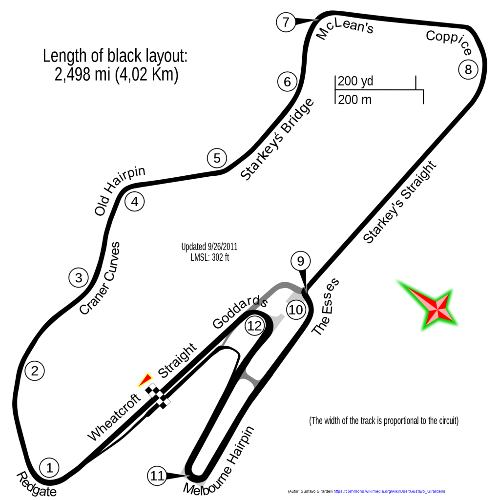
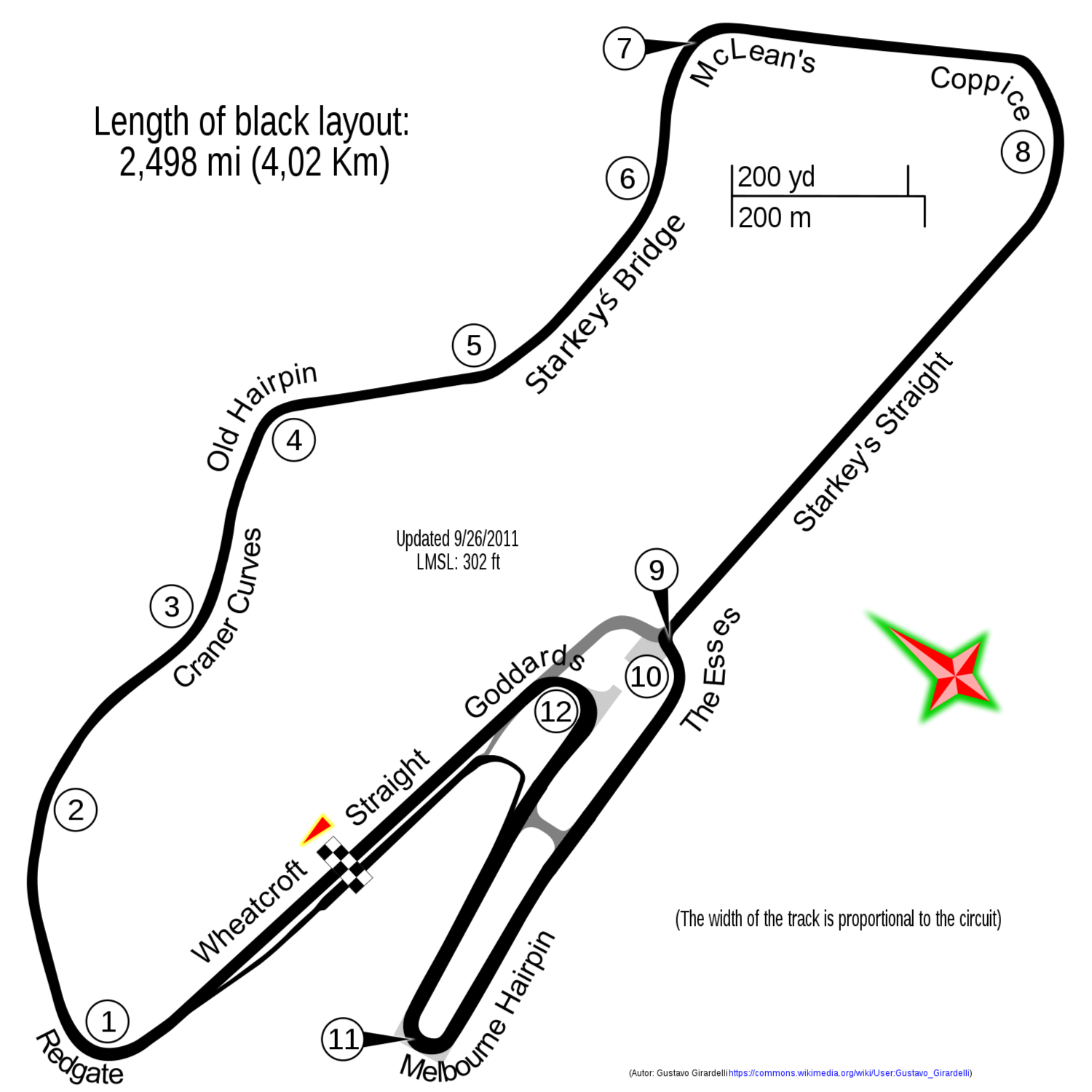
Español: Circuito de Donington Park, calcado de OpenStreetMap con adiciones propias. |
|||
| Date | ||||
| Source |
|
|||
| Author | Gustavo Girardelli |
| Camera location | | View this and other nearby images on: OpenStreetMap |
|---|
Licensing
edit
I, the copyright holder of this work, hereby publish it under the following license:
This file is licensed under the Creative Commons Attribution-Share Alike 4.0 International license.
- You are free:
- to share – to copy, distribute and transmit the work
- to remix – to adapt the work
- Under the following conditions:
- attribution – You must give appropriate credit, provide a link to the license, and indicate if changes were made. You may do so in any reasonable manner, but not in any way that suggests the licensor endorses you or your use.
- share alike – If you remix, transform, or build upon the material, you must distribute your contributions under the same or compatible license as the original.
File history
Click on a date/time to view the file as it appeared at that time.
| Date/Time | Thumbnail | Dimensions | User | Comment | |
|---|---|---|---|---|---|
| current | 00:40, 16 April 2021 | | 1,500 × 1,500 (281 KB) | Fuhghettaboutit (talk | contribs) | Add missing ending "t" to "Starkey's straigh". |
| 17:57, 7 June 2016 |  | 1,500 × 1,500 (183 KB) | Gpmat (talk | contribs) | trying to fix | |
| 17:51, 7 June 2016 |  | 1,500 × 1,500 (181 KB) | Gpmat (talk | contribs) | trying to remove unwanted black rectangle | |
| 22:33, 8 April 2015 |  | 1,500 × 1,500 (181 KB) | Gustavo Girardelli (talk | contribs) | Reverted to version as of 17:56, 8 April 2015 | |
| 22:33, 8 April 2015 |  | 1,500 × 1,500 (84 KB) | Gustavo Girardelli (talk | contribs) | Reverted to version as of 17:31, 8 April 2015 | |
| 17:57, 8 April 2015 |  | 1,500 × 1,500 (75 KB) | Gustavo Girardelli (talk | contribs) | Reverted to version as of 16:46, 8 April 2015 | |
| 17:56, 8 April 2015 |  | 1,500 × 1,500 (84 KB) | Gustavo Girardelli (talk | contribs) | Reverted to version as of 17:31, 8 April 2015 | |
| 17:56, 8 April 2015 |  | 1,500 × 1,500 (181 KB) | Gustavo Girardelli (talk | contribs) | Reverted to version as of 17:49, 8 April 2015 | |
| 17:53, 8 April 2015 |  | 1,500 × 1,500 (75 KB) | Gustavo Girardelli (talk | contribs) | Reverted to version as of 16:46, 8 April 2015 | |
| 17:51, 8 April 2015 |  | 1,500 × 1,500 (181 KB) | Gustavo Girardelli (talk | contribs) | Sin falla commons |
You cannot overwrite this file.
File usage on Commons
The following 9 pages use this file:
- User:Chumwa/OgreBot/Potential transport maps/2016 June 1-10
- User:Chumwa/OgreBot/Transport Maps/2015 April 1-10
- User:Chumwa/OgreBot/Transport Maps/2016 June 1-10
- User:Chumwa/OgreBot/Transport Maps/2021 April 11-20
- User:Chumwa/OgreBot/Travel and communication maps/2016 June 1-10
- User:Giragus
- User:Gustavo Girardelli
- User:Gustavo Girardelli/credit
- File:Donington as of 2010.svg
File usage on other wikis
The following other wikis use this file:
- Usage on ar.wikipedia.org
- Usage on bg.wikipedia.org
- Usage on br.wikipedia.org
- Usage on en.wikipedia.org
- Donington Park
- British motorcycle Grand Prix
- FIA WTCC Race of UK
- List of European Le Mans Series circuits
- Wikipedia:Graphics Lab/Map workshop/Archive/Nov 2010
- 2011 Donington Superbike World Championship round
- 2012 Donington Superbike World Championship round
- 2011 FIA WTCC Race of UK
- User:FactualCollector7d1/sandbox
- 2012 Superstars Series Donington round
- 2016 Donington Park Superbike World Championship round
- List of FIA World Touring Car Championship circuits
- Usage on es.wikipedia.org
- Usage on fa.wikipedia.org
- Usage on gl.wikipedia.org
- Usage on hr.wikipedia.org
- Usage on hu.wikipedia.org
- Usage on id.wikipedia.org
- Usage on it.wikipedia.org
- Usage on ja.wikipedia.org
- Usage on pl.wikipedia.org
- Usage on pt.wikipedia.org
- Usage on ru.wikipedia.org
- Usage on simple.wikipedia.org
- Usage on uk.wikipedia.org
- Usage on zh.wikipedia.org