File:Donja Dubrava municipality location.png
No higher resolution available.
Donja_Dubrava_municipality_location.png (283 × 168 pixels, file size: 3 KB, MIME type: image/png)
Captions
Captions
Add a one-line explanation of what this file represents
Summary edit
| Description |
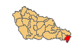
This file was uploaded with Commonist. Hrvatski: Položaj općine Donja Dubrava unutar Međimurske županije
English: Location of Donja Dubrava municipality inside Međimurje County |
| Date | |
| Source | File:Croatia_map_municipalities.gif |
| Author | oroginal file by Suradnik13 , cropping and retouching by myself |
Licensing edit
This file is licensed under the Creative Commons Attribution-Share Alike 3.0 Unported license.
- You are free:
- to share – to copy, distribute and transmit the work
- to remix – to adapt the work
- Under the following conditions:
- attribution – You must give appropriate credit, provide a link to the license, and indicate if changes were made. You may do so in any reasonable manner, but not in any way that suggests the licensor endorses you or your use.
- share alike – If you remix, transform, or build upon the material, you must distribute your contributions under the same or compatible license as the original.
Original upload log edit
| Date/Time | Dimensions | User | Comment |
|---|---|---|---|
| 15 February 2013, 09:50:39 | 283 × 168 (2775 bytes) | Quahadi (talk · contribs) |
File history
Click on a date/time to view the file as it appeared at that time.
| Date/Time | Thumbnail | Dimensions | User | Comment | |
|---|---|---|---|---|---|
| current | 04:44, 5 January 2015 | | 283 × 168 (3 KB) | GifTagger (talk | contribs) | Bot: Converting file to superior PNG file. (Source: Donja_Dubrava_municipality_location.GIF). This GIF was problematic due to non-greyscale color table. |
You cannot overwrite this file.
File usage on Commons
The following 2 pages use this file:
- User:Quahadi/gallery
- File:Donja Dubrava municipality location.GIF (file redirect)
File usage on other wikis
The following other wikis use this file:
- Usage on en.wikipedia.org
- Usage on ru.wikipedia.org