File:Dool om Bergh 1001 041.jpg

Size of this preview: 280 × 598 pixels. Other resolutions: 112 × 240 pixels | 468 × 1,000 pixels.
Original file (468 × 1,000 pixels, file size: 178 KB, MIME type: image/jpeg)
Captions
Captions
Add a one-line explanation of what this file represents
Summary
edit
| Description |
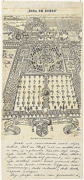
English: Map of the 17th c. estate Dool-om-Berg near Amersfoort with 19th c. annotations by A.M. Tromp van Holst
Nederlands: 17e eeuwse kaart van Dool-om-Berg (voormalig landgoed) bij Amersfoort met aantekeningen van A.M. Tromp van Holst. In de eerste helft van de 20e eeuw kwam er woningbouw voor in de plaats |
| Date | (1895) |
| Source | http://www.regiocanons.nl/utrecht/eemland/buitenplaatsen/beeld--geluid/dool-om-bergh |
| Author | Everard Meyster |
Licensing
edit
|
This work is in the public domain in its country of origin and other countries and areas where the copyright term is the author's life plus 100 years or fewer. | |
| This file has been identified as being free of known restrictions under copyright law, including all related and neighboring rights. | |
File history
Click on a date/time to view the file as it appeared at that time.
| Date/Time | Thumbnail | Dimensions | User | Comment | |
|---|---|---|---|---|---|
| current | 18:40, 27 June 2011 | | 468 × 1,000 (178 KB) | Joostik (talk | contribs) | {{Information |Description ={{en|1=Map of the 17th c. estate Dool-om-Berg near Amersfoort with 19th c. annotations by A.M. Tromp van Holst}} {{nl|1=17e eeuwse kaart van Dool-om-Berg bij Amersfoort met aantekeningen van A.M. Tromp van Holst}} |Source |
You cannot overwrite this file.
File usage on Commons
There are no pages that use this file.
File usage on other wikis
The following other wikis use this file:
- Usage on nl.wikipedia.org
- Usage on www.wikidata.org