File:Dowdy Ranch Visitor's Center Kaiser-Aetna Road North Fork Pacheco Creek USGS MAP Pine Ridge Association.png

Size of this preview: 460 × 600 pixels. Other resolutions: 184 × 240 pixels | 368 × 480 pixels | 589 × 768 pixels | 1,275 × 1,662 pixels.
Original file (1,275 × 1,662 pixels, file size: 2.93 MB, MIME type: image/png)
Captions
Captions
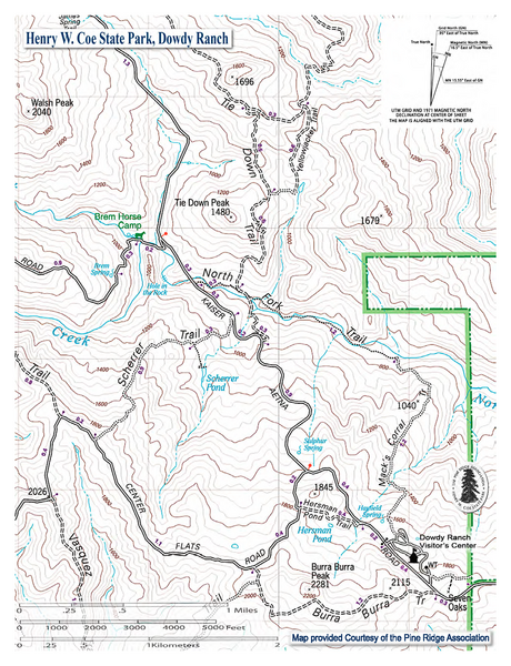
Map of southeastern Henry Coe State Park in the Diablo Range of California, showing North Fork Pacheco Creek
Summary edit
| Description |
English: Map of southeastern Henry Coe State Park in the Diablo Range of California, showing North Fork Pacheco Creek |
| Date | |
| Source | https://coepark.net/images/maps/dowdy_vc_area.pdf |
| Author | United States Geological Survey Map and Pine Ridge Association/Henry Coe State Park |
Licensing edit
This work is in the public domain in the United States because it is a work prepared by an officer or employee of the United States Government as part of that person’s official duties under the terms of Title 17, Chapter 1, Section 105 of the US Code.
Note: This only applies to original works of the Federal Government and not to the work of any individual U.S. state, territory, commonwealth, county, municipality, or any other subdivision. This template also does not apply to postage stamp designs published by the United States Postal Service since 1978. (See § 313.6(C)(1) of Compendium of U.S. Copyright Office Practices). It also does not apply to certain US coins; see The US Mint Terms of Use.
|
 | |
| This file has been identified as being free of known restrictions under copyright law, including all related and neighboring rights. | ||
File history
Click on a date/time to view the file as it appeared at that time.
| Date/Time | Thumbnail | Dimensions | User | Comment | |
|---|---|---|---|---|---|
| current | 23:54, 7 December 2021 | | 1,275 × 1,662 (2.93 MB) | Schmiebel (talk | contribs) | Uploaded a work by United States Geological Survey Map and Pine Ridge Association/Henry Coe State Park from https://coepark.net/images/maps/dowdy_vc_area.pdf with UploadWizard |
You cannot overwrite this file.
File usage on Commons
There are no pages that use this file.
File usage on other wikis
The following other wikis use this file:
- Usage on en.wikipedia.org