File:Dowles Bridge remains and River Severn - geograph.org.uk - 869503.jpg

Size of this preview: 800 × 559 pixels. Other resolutions: 320 × 223 pixels | 640 × 447 pixels | 1,024 × 715 pixels.
Original file (1,024 × 715 pixels, file size: 259 KB, MIME type: image/jpeg)
Captions
Captions
Add a one-line explanation of what this file represents
Summary
edit
| Description |
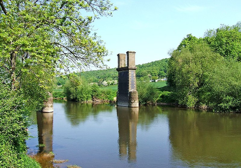
English: Dowles Bridge remains and River Severn Only the pillars remain of the Dowles Bridge which carried the railway line from Bewdley to Tenbury, through the Wyre Forest, and on to the junction with the Welsh Marches Line at Woofferton. The line closed in 1964 and the bridge was partially dismantled the same year. |
| Date | |
| Source | From geograph.org.uk |
| Author | P L Chadwick |
| Attribution (required by the license) | P L Chadwick / Dowles Bridge remains and River Severn / |
| Camera location | | View this and other nearby images on: OpenStreetMap |
|---|
_heading:0.00&language=en)
| Object location | | View this and other nearby images on: OpenStreetMap |
|---|
_heading:0.00&language=en)
Licensing
edit

|
This image was taken from the Geograph project collection. See this photograph's page on the Geograph website for the photographer's contact details. The copyright on this image is owned by P L Chadwick and is licensed for reuse under the Creative Commons Attribution-ShareAlike 2.0 license.
|
This file is licensed under the Creative Commons Attribution-Share Alike 2.0 Generic license.
Attribution: P L Chadwick
- You are free:
- to share – to copy, distribute and transmit the work
- to remix – to adapt the work
- Under the following conditions:
- attribution – You must give appropriate credit, provide a link to the license, and indicate if changes were made. You may do so in any reasonable manner, but not in any way that suggests the licensor endorses you or your use.
- share alike – If you remix, transform, or build upon the material, you must distribute your contributions under the same or compatible license as the original.
File history
Click on a date/time to view the file as it appeared at that time.
| Date/Time | Thumbnail | Dimensions | User | Comment | |
|---|---|---|---|---|---|
| current | 19:57, 31 August 2017 | | 1,024 × 715 (259 KB) | Geograph Update Bot (talk | contribs) | Higher-resolution version from Geograph. |
| 05:24, 21 February 2011 |  | 640 × 447 (124 KB) | GeographBot (talk | contribs) | == {{int:filedesc}} == {{Information |description={{en|1=Dowles Bridge remains and River Severn Only the pillars remain of the Dowles Bridge which carried the railway line from Bewdley to Tenbury, through the Wyre Forest, and on to the junction with the W |
You cannot overwrite this file.
File usage on Commons
There are no pages that use this file.