File:Dros Lyn Ystumllyn i Foel y Gest - Across Llyn Ystumllyn to Moel y Gest - geograph.org.uk - 953425.jpg
No higher resolution available.
Dros_Lyn_Ystumllyn_i_Foel_y_Gest_-_Across_Llyn_Ystumllyn_to_Moel_y_Gest_-_geograph.org.uk_-_953425.jpg (640 × 428 pixels, file size: 84 KB, MIME type: image/jpeg)
Captions
Captions
Add a one-line explanation of what this file represents
Summary
edit
| Description |
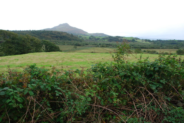
English: Dros Lyn Ystumllyn i Foel y Gest - Across Llyn Ystumllyn to Moel y Gest The tautologously named Llyn Ystumllyn (Lake of the meandering lake) once virtually surrounded the church of St Cynhaearn on Ynyscynhaearn (Cynhaearn's Island). Although still marked on the OS maps, the lake was largely drained into the sea near Y Greigddu (Blackrock) in the 19th century. The river running through the remaining wetlands is now called Afon Cedron, but was formerly Afon Dowarch. The earlier name of the village of Pentrefelin was Aberdowarch.
In the background is the bulk of Moel y Gest and below it to the right Y Greigddu (Blackrock). |
| Date | |
| Source | From geograph.org.uk |
| Author | Alan Fryer |
| Attribution (required by the license) | Alan Fryer / Dros Lyn Ystumllyn i Foel y Gest - Across Llyn Ystumllyn to Moel y Gest / |
| Camera location | | View this and other nearby images on: OpenStreetMap |
|---|
_heading:112.00&language=en)
| Object location | | View this and other nearby images on: OpenStreetMap |
|---|
_heading:112.00&language=en)
Licensing
edit

|
This image was taken from the Geograph project collection. See this photograph's page on the Geograph website for the photographer's contact details. The copyright on this image is owned by Alan Fryer and is licensed for reuse under the Creative Commons Attribution-ShareAlike 2.0 license.
|
This file is licensed under the Creative Commons Attribution-Share Alike 2.0 Generic license.
Attribution: Alan Fryer
- You are free:
- to share – to copy, distribute and transmit the work
- to remix – to adapt the work
- Under the following conditions:
- attribution – You must give appropriate credit, provide a link to the license, and indicate if changes were made. You may do so in any reasonable manner, but not in any way that suggests the licensor endorses you or your use.
- share alike – If you remix, transform, or build upon the material, you must distribute your contributions under the same or compatible license as the original.
File history
Click on a date/time to view the file as it appeared at that time.
| Date/Time | Thumbnail | Dimensions | User | Comment | |
|---|---|---|---|---|---|
| current | 13:03, 22 February 2011 | | 640 × 428 (84 KB) | GeographBot (talk | contribs) | == {{int:filedesc}} == {{Information |description={{en|1=Dros Lyn Ystumllyn i Foel y Gest - Across Llyn Ystumllyn to Moel y Gest The tautologously named Llyn Ystumllyn (Lake of the meandering lake) once virtually surrounded the church of St Cynhaearn on Y |
You cannot overwrite this file.
File usage on Commons
There are no pages that use this file.