File:Drought in Mexico (MODIS 2024-02-27).jpg

Original file (5,189 × 4,301 pixels, file size: 3.26 MB, MIME type: image/jpeg)
Captions
Captions
Summary edit
.jpg&action=edit§ion=1)
| Description |
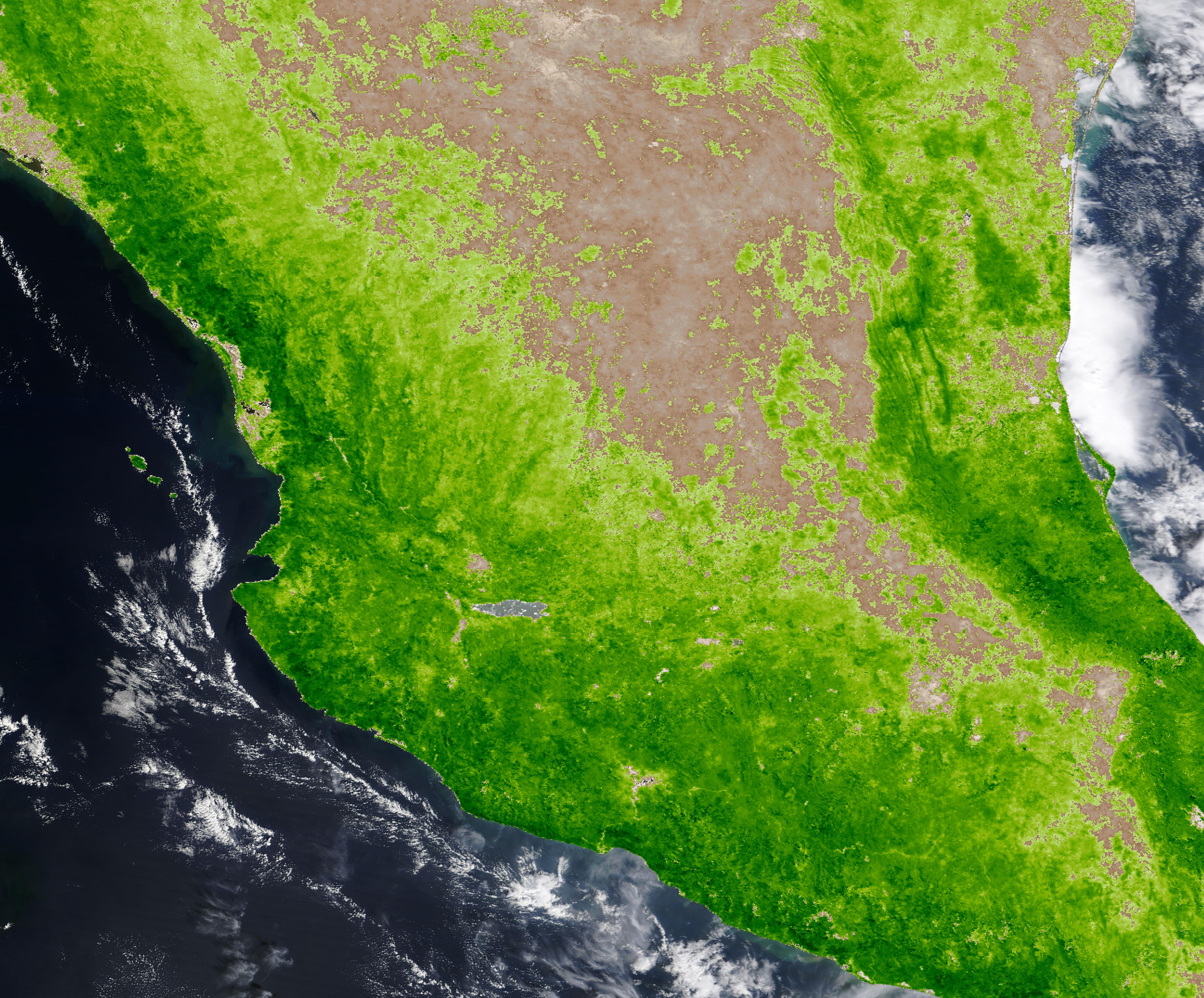
English: October 26, 2023 October 25, 2021
Faced with warming temperatures, widespread reduction in rainfall, and increasing population, Northern and Central Mexico have been struggling with long-term drought for several years. By late 2023, water shortages became critical as far south as Mexico City. According to a February 15, 2024, report by Conagua, Mexico’s national water commission, about 59.86 percent of the country is currently experiencing moderate to exceptional drought. Water shortages have been taking an increasing toll on Mexico City, which is home to about 22.5 people. An estimated 90 percent of the city sits in a “severe drought” location, according to the Conagua map. A network of three reservoirs, known as the Cutzamala system, provides roughly 25 percent of water to Mexico City and the surrounding valley. Due to the ongoing drought, Conagua decided in October 2023 to restrict water from the system by 8 percent. Several weeks later, they reduced the supply further, reaching nearly 25 percent restriction. In late January 2024, CNN reported that the Cutzamala system was at historic lows, at only 39 percent capacity. On January 26, Mexico News Daily reported that officials implemented water restrictions in 284 of Mexico City’s neighborhoods, which represent about 15 percent of the city’s neighborhoods. The report stated, “Residents in these areas will now only receive water on certain days of the week and for limited periods of time, according to municipal authorities.” Today’s Image of the Day compares two images acquired by data from the Moderate Resolution Imaging Spectroradiometer (MODIS) on NASA’s Aqua satellite, one acquired on October 26, 2023, and one acquired on October 25, 2021. The images have been created by using the MODIS Aqua L3 Monthly Enhanced Vegetation Index (EVI) data product. This type of image shows open land as tan and vegetation as green. Areas of heavy vegetation appear darker green, while water looks deep blue or black. A large amount of vegetation suggests adequate water in the soil, while scant or no vegetation strongly suggests low soil moisture (drought). Toggling between the two images by clicking on the dates will show the landcover change over time. In April 2021, Mexico was experiencing what was then one of its most widespread and intense droughts in decades, with 85 percent of the country facing drought conditions, according to an article published by NASA’s Earth Observatory on May 5, 2021. Despite those harsh conditions, the October 2021 image still shows much more widespread vegetation compared to October 2023. The expanding drought, highlighted by extensive tan land, is obvious by October 2023. |
||
| Date | Taken on 26 October 2023 | ||
| Source |
Drought in Mexico (direct link)
|
||
| Author | MODIS Land Rapid Response Team, NASA GSFC |
| This media is a product of the Aqua mission Credit and attribution belongs to the mission team, if not already specified in the "author" row |
Licensing edit
.jpg&action=edit§ion=2)
| This file is in the public domain in the United States because it was solely created by NASA. NASA copyright policy states that "NASA material is not protected by copyright unless noted". (See Template:PD-USGov, NASA copyright policy page or JPL Image Use Policy.) | ||
 |
Warnings:
|
File history
Click on a date/time to view the file as it appeared at that time.
| Date/Time | Thumbnail | Dimensions | User | Comment | |
|---|---|---|---|---|---|
| current | 05:05, 27 February 2024 | | 5,189 × 4,301 (3.26 MB) | OptimusPrimeBot (talk | contribs) | #Spacemedia - Upload of http://modis.gsfc.nasa.gov/gallery/images/image02272024_250m.jpg via Commons:Spacemedia |
You cannot overwrite this file.
File usage on Commons
There are no pages that use this file.
.jpg&oldid=856391557)