File:Drygalski Glacier, Antártica.jpg

Size of this preview: 800 × 450 pixels. Other resolutions: 320 × 180 pixels | 640 × 360 pixels | 1,024 × 576 pixels | 1,280 × 720 pixels | 2,560 × 1,440 pixels | 3,808 × 2,142 pixels.
Original file (3,808 × 2,142 pixels, file size: 3.01 MB, MIME type: image/jpeg)
Captions
Captions
Add a one-line explanation of what this file represents
Summary
edit
| Description |
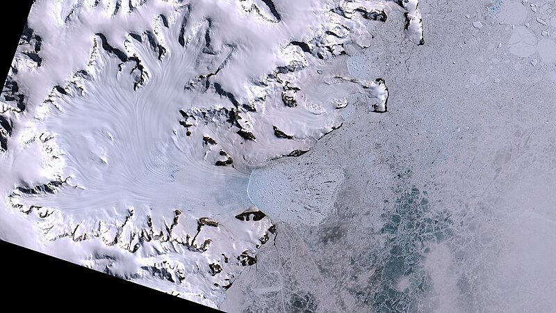
Português: Final da Geleira Drygalski na Baía Solari, Mar de Weddell, onde até 1995 ficava a Plataforma de Gelo colapsada Larsen A. Após a linha branca no centro da imagem que delimita a geleira, pedaços dela misturado ao gelo marinho em tom azulado, pedaços de banquisa e fendas de mar aberto em preto. Embaixo à dir., em cinza escuro banquisa ainda íntegra, mas já fina nas áreas mais escuras. Rochas e solo expostos em marrom escuro e preto. Neve em branco. A geleira vem do meio da imagem à esq. para o centro, com a direção do seu fluxo marcada por linhas, que são cruzadas por rachaduras em branco azulado pelo gelo profundo exposto ao seu final antes de chegar ao mar / Drygalski Glacier ends at Weddell Sea´s Solari Bay, where until 1995 was Larsen A Ice Shelf. After white line marking its end at image center, there is sea ice floats mixed with its floating pieces, in blueish white, and open sea in black. Below to the right, still frozen ice sea in gray, thinner at darker areas. Rock ad exposed soil in brown and black. Snow in white. Glacier comes from imge left side center to image center, with its flow direction marked by lines, crossed at its end, before arriving at sea by cracks in blueish white, due to exposed deep ice.
Imagem / Image CBERS4 MUX Geleira Drygalski / Drygalski Glacier, Antártica. Coordenadas do centro da imagem / Image center: 64°43'00.2"S 60°43'59.9"W Data / Date: 20-01-2020 / 2020-20-01 RGB 765 (cor verdadeira / true color) Cena / Scene: 150 / 173 Autor / Author: Oton Barros (DSR/OBT/INPE) Imagem em HD / HD Image Visite-nos em www.dsr.inpe.br |
| Date | |
| Source | https://www.flickr.com/photos/153282474@N02/49460467086/ |
| Author | Coordenação-Geral de Observação da Terra/INPE |
Licensing
edit
This file is licensed under the Creative Commons Attribution-Share Alike 2.0 Generic license.
- You are free:
- to share – to copy, distribute and transmit the work
- to remix – to adapt the work
- Under the following conditions:
- attribution – You must give appropriate credit, provide a link to the license, and indicate if changes were made. You may do so in any reasonable manner, but not in any way that suggests the licensor endorses you or your use.
- share alike – If you remix, transform, or build upon the material, you must distribute your contributions under the same or compatible license as the original.
| This image was originally posted to Flickr by Coordenação-Geral de Observação da Terra/INPE at https://flickr.com/photos/153282474@N02/49460467086. It was reviewed on 9 April 2020 by FlickreviewR 2 and was confirmed to be licensed under the terms of the cc-by-sa-2.0. |
File history
Click on a date/time to view the file as it appeared at that time.
| Date/Time | Thumbnail | Dimensions | User | Comment | |
|---|---|---|---|---|---|
| current | 10:12, 9 April 2020 | | 3,808 × 2,142 (3.01 MB) | Jo-Jo Eumerus (talk | contribs) | Uploaded a work by Coordenação-Geral de Observação da Terra/INPE from https://www.flickr.com/photos/153282474@N02/49460467086/ with UploadWizard |
You cannot overwrite this file.
File usage on Commons
The following 2 pages use this file:
.jpg&redirect=no)
File usage on other wikis
The following other wikis use this file:
- Usage on ceb.wikipedia.org
- Usage on de.wikipedia.org
- Usage on nn.wikipedia.org
- Usage on www.wikidata.org