File:Duesaigues.jpg

Size of this preview: 800 × 450 pixels. Other resolutions: 320 × 180 pixels | 640 × 360 pixels | 1,024 × 576 pixels | 1,280 × 720 pixels | 2,926 × 1,646 pixels.
Original file (2,926 × 1,646 pixels, file size: 6.58 MB, MIME type: image/jpeg)
Captions
Captions
Add a one-line explanation of what this file represents
Summary
edit
| Description |
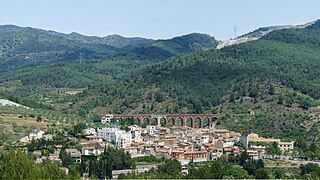
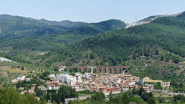
English: Duesaigües
Català: Duesaigües |
| Date | |
| Source | Own work |
| Author | Tabalot |
| Camera location | | View this and other nearby images on: OpenStreetMap |
|---|
Licensing
edit
| I, the copyright holder of this work, release this work into the public domain. This applies worldwide. In some countries this may not be legally possible; if so: I grant anyone the right to use this work for any purpose, without any conditions, unless such conditions are required by law. |
File history
Click on a date/time to view the file as it appeared at that time.
| Date/Time | Thumbnail | Dimensions | User | Comment | |
|---|---|---|---|---|---|
| current | 14:46, 28 October 2021 | | 2,926 × 1,646 (6.58 MB) | Lojwe (talk | contribs) | Corrección del ruido y la perspectiva |
| 21:49, 6 October 2020 |  | 2,926 × 1,646 (7.05 MB) | Lojwe (talk | contribs) | Mejora de la definición | |
| 16:43, 31 May 2009 |  | 2,926 × 1,646 (3.64 MB) | Tabalot (talk | contribs) | {{Information |Description={{en|1=Duesaigües}} {{ca|1=Duesaigües}} |Source=Obra pròpia (own work) |Author=Tabalot |Date=31/05/2009 |Permission= |other_versions= }} {{location|41|8|19.86|N|0|55|44.43|E}} <!--{{ImageUpload|full}}--> [[Ca |
You cannot overwrite this file.
File usage on Commons
The following 3 pages use this file:
File usage on other wikis
The following other wikis use this file:
- Usage on an.wikipedia.org
- Usage on ca.wikipedia.org
- Usage on ceb.wikipedia.org
- Usage on ce.wikipedia.org
- Usage on de.wikipedia.org
- Usage on en.wikipedia.org
- Usage on es.wikipedia.org
- Usage on eu.wikipedia.org
- Usage on fa.wikipedia.org
- Usage on fr.wikipedia.org
- Usage on gl.wikipedia.org
- Usage on hu.wikipedia.org
- Usage on hy.wikipedia.org
- Usage on ia.wikipedia.org
- Usage on it.wikipedia.org
- Usage on la.wikipedia.org
- Usage on lld.wikipedia.org
- Usage on lmo.wikipedia.org
- Usage on pl.wikipedia.org
- Usage on pt.wikipedia.org
- Usage on ru.wikipedia.org
- Usage on sv.wikipedia.org
- Usage on tt.wikipedia.org
- Usage on uz.wikipedia.org
- Usage on vec.wikipedia.org
- Usage on vi.wikipedia.org
- Usage on www.wikidata.org