File:Dumbarton Rock, Duke of Argyll's Battery - geograph.org.uk - 1381365.jpg
Dumbarton_Rock,_Duke_of_Argyll's_Battery_-_geograph.org.uk_-_1381365.jpg (640 × 480 pixels, file size: 91 KB, MIME type: image/jpeg)
Captions
Captions
Summary
edit
| Description |
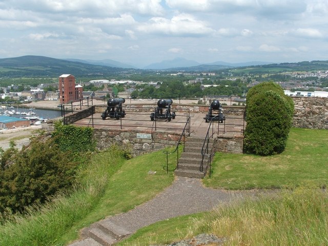
English: Dumbarton Rock: Duke of Argyll's Battery [This is one of a linked series of articles about Dumbarton Rock. See the end of 1380091 for a list of the reference works that are cited here in abbreviated form.]
Belhouse (or Bellhouse) Battery formerly stood on this site; it was modified in about 1795 to take heavier guns, at which time it was given its present name [OSG07, p5; MacPhail, p134-5, 186]. The background of the image shows a view northwards along the length of the Vale of Leven; Ben Lomond (NN3602) is visible on the skyline, just to the right of the middle cannon. The tall brick-red structure on the left is the shell of the huge Ballantine's distillery (see https://www.geograph.org.uk/photo/1442360 ). Previous: 1381295. Next: 1381450. |
| Date | |
| Source | From geograph.org.uk |
| Author | Lairich Rig |
| Attribution (required by the license) | Lairich Rig / Dumbarton Rock: Duke of Argyll's Battery / |
| Camera location | | View this and other nearby images on: OpenStreetMap |
|---|
_heading:0.00&language=en)
| Object location | | View this and other nearby images on: OpenStreetMap |
|---|
_heading:0.00&language=en)
Licensing
edit

|
This image was taken from the Geograph project collection. See this photograph's page on the Geograph website for the photographer's contact details. The copyright on this image is owned by Lairich Rig and is licensed for reuse under the Creative Commons Attribution-ShareAlike 2.0 license.
|
- You are free:
- to share – to copy, distribute and transmit the work
- to remix – to adapt the work
- Under the following conditions:
- attribution – You must give appropriate credit, provide a link to the license, and indicate if changes were made. You may do so in any reasonable manner, but not in any way that suggests the licensor endorses you or your use.
- share alike – If you remix, transform, or build upon the material, you must distribute your contributions under the same or compatible license as the original.
File history
Click on a date/time to view the file as it appeared at that time.
| Date/Time | Thumbnail | Dimensions | User | Comment | |
|---|---|---|---|---|---|
| current | 18:14, 28 February 2011 | | 640 × 480 (91 KB) | GeographBot (talk | contribs) | == {{int:filedesc}} == {{Information |description={{en|1=Dumbarton Rock: Duke of Argyll's Battery [This is one of a linked series of articles about Dumbarton Rock. See the end of http://www.geograph.org.uk/photo/1380091 for a list of the reference works t |
You cannot overwrite this file.
File usage on Commons
There are no pages that use this file.