File:Dura Europos plan.png

Size of this preview: 513 × 600 pixels. Other resolutions: 205 × 240 pixels | 410 × 480 pixels | 657 × 768 pixels | 1,200 × 1,403 pixels.
Original file (1,200 × 1,403 pixels, file size: 461 KB, MIME type: image/png)
Captions
Captions
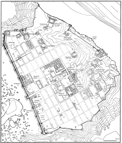
Site plan of Dura-Europos showing extent of excavation and naming major monuments and city blocks, modified from plan by A. H. Detweiler, YUAG
Summary
edit
| Description |
English: Site plan of Dura-Europos showing extent of excavation and naming major monuments and city blocks, modified from plan by A. H. Detweiler, YUAG |
| Date | 1930s |
| Source | https://traj.openlibhums.org/article/id/4016/ |
| Author | J. A. Baird |
Licensing
edit
This file is licensed under the Creative Commons Attribution 4.0 International license.
- You are free:
- to share – to copy, distribute and transmit the work
- to remix – to adapt the work
- Under the following conditions:
- attribution – You must give appropriate credit, provide a link to the license, and indicate if changes were made. You may do so in any reasonable manner, but not in any way that suggests the licensor endorses you or your use.
File history
Click on a date/time to view the file as it appeared at that time.
| Date/Time | Thumbnail | Dimensions | User | Comment | |
|---|---|---|---|---|---|
| current | 17:44, 18 December 2021 | | 1,200 × 1,403 (461 KB) | Artem.G (talk | contribs) | Uploaded a work by J. A. Baird from https://traj.openlibhums.org/article/id/4016/ with UploadWizard |
You cannot overwrite this file.
File usage on Commons
There are no pages that use this file.