File:Durban Trolleybus Map.png

Size of this preview: 571 × 600 pixels. Other resolutions: 228 × 240 pixels | 457 × 480 pixels | 731 × 768 pixels | 975 × 1,024 pixels | 2,000 × 2,101 pixels.
Original file (2,000 × 2,101 pixels, file size: 3.03 MB, MIME type: image/png)
Captions
Captions
Add a one-line explanation of what this file represents
Summary edit
| Description |
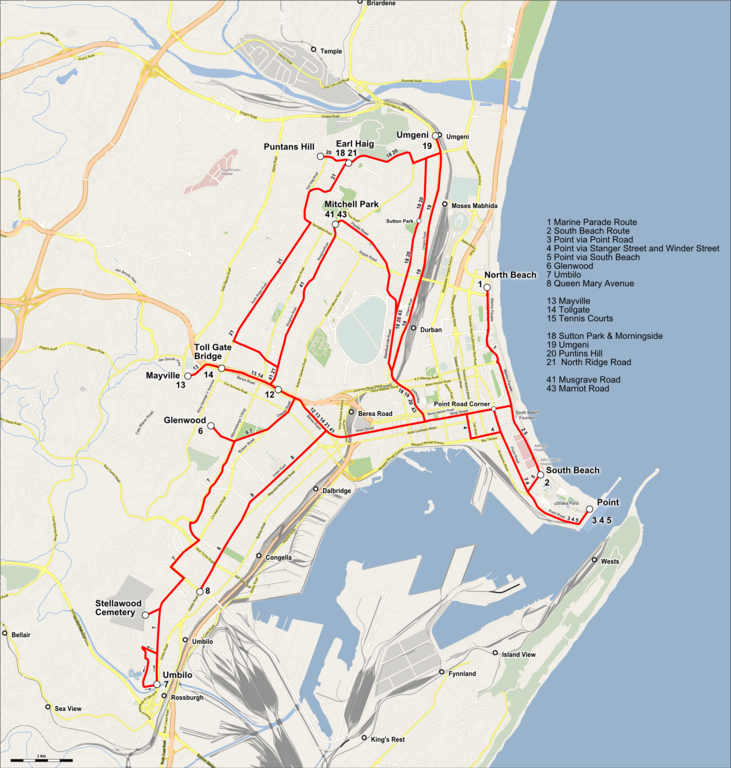
English: Map of the network of the Trolleybuses in Durban. Deutsch: Karte der Oberleitungsbuslinien in Durban, Südafrika |
| Date | |
| Source |
Map was created by using
|
| Author |
|
| Permission (Reusing this file) |
Map data (c) OpenStreetMap (and) contributors, CC-BY-SA |
Licensing edit
| This work is licensed under the Open Database License (summary). |
This file is licensed under the Creative Commons Attribution-Share Alike 2.0 Generic license.
Attribution: Peter Christener
- You are free:
- to share – to copy, distribute and transmit the work
- to remix – to adapt the work
- Under the following conditions:
- attribution – You must give appropriate credit, provide a link to the license, and indicate if changes were made. You may do so in any reasonable manner, but not in any way that suggests the licensor endorses you or your use.
- share alike – If you remix, transform, or build upon the material, you must distribute your contributions under the same or compatible license as the original.
File history
Click on a date/time to view the file as it appeared at that time.
| Date/Time | Thumbnail | Dimensions | User | Comment | |
|---|---|---|---|---|---|
| current | 11:57, 5 July 2017 | | 2,000 × 2,101 (3.03 MB) | Pechristener (talk | contribs) | kleine Korrekturen |
| 19:40, 3 July 2017 |  | 2,000 × 2,101 (2.69 MB) | Pechristener (talk | contribs) | kleiner Fehler im Meer | |
| 19:37, 3 July 2017 |  | 2,000 × 2,101 (2.72 MB) | Pechristener (talk | contribs) | neue kleinere Datei | |
| 13:44, 3 July 2017 |  | 7,104 × 7,462 (14.26 MB) | Pechristener (talk | contribs) | {{Information |Description={{en|Map of the network of the {{w|Trolleybuses in Durban}}.}}{{de|Karte der Oberleitungsbuslinien in Durban, Südafrika}} |Source=Map was created by using * [http://www.openstreetmap.org/ Open Street Map] Data * Information... |
You cannot overwrite this file.
File usage on Commons
The following page uses this file:
File usage on other wikis
The following other wikis use this file:
- Usage on de.wikipedia.org
- Usage on en.wikipedia.org
- Usage on www.wikidata.org
- Usage on zh.wikipedia.org