File:E22RtMap.png
Size of this preview: 800 × 298 pixels. Other resolutions: 320 × 119 pixels | 640 × 238 pixels | 1,024 × 381 pixels | 1,280 × 477 pixels | 2,560 × 954 pixels | 5,707 × 2,126 pixels.
Original file (5,707 × 2,126 pixels, file size: 1.34 MB, MIME type: image/png)
Captions
Captions
Add a one-line explanation of what this file represents
Summary
edit
| Description |
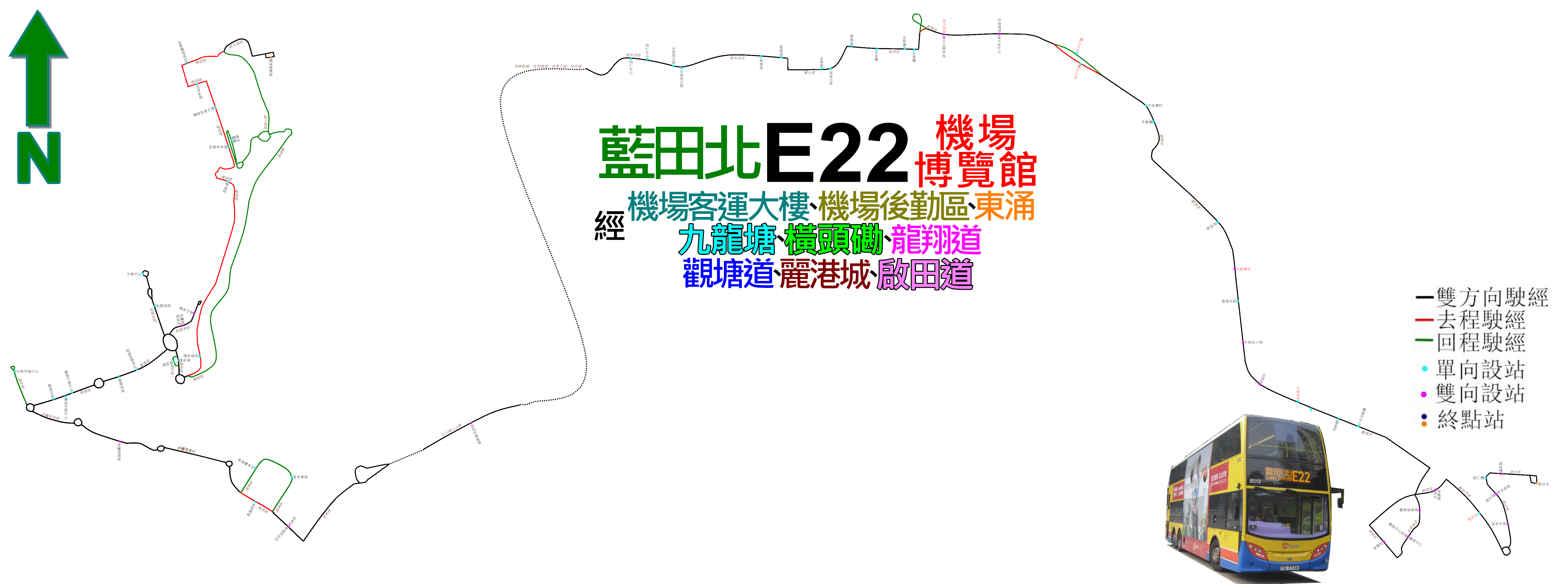
中文(香港):城巴E22線的走線圖 |
| Date | |
| Source | Own work |
| Author | ATR50 |
Licensing
edit
I, the copyright holder of this work, hereby publish it under the following license:
This file is licensed under the Creative Commons Attribution-Share Alike 3.0 Unported license.
- You are free:
- to share – to copy, distribute and transmit the work
- to remix – to adapt the work
- Under the following conditions:
- attribution – You must give appropriate credit, provide a link to the license, and indicate if changes were made. You may do so in any reasonable manner, but not in any way that suggests the licensor endorses you or your use.
- share alike – If you remix, transform, or build upon the material, you must distribute your contributions under the same or compatible license as the original.
File history
Click on a date/time to view the file as it appeared at that time.
| Date/Time | Thumbnail | Dimensions | User | Comment | |
|---|---|---|---|---|---|
| current | 15:30, 23 December 2017 | 5,707 × 2,126 (1.34 MB) | ATR50~commonswiki (talk | contribs) | 2017年5月配合採用12.8米行駛而修改麗港城走線 | |
| 15:45, 23 July 2016 | 5,707 × 2,126 (1.36 MB) | ATR50~commonswiki (talk | contribs) | 2016年7月改良 | ||
| 17:26, 8 May 2014 | 5,707 × 2,126 (1.18 MB) | ATR50~commonswiki (talk | contribs) | User created page with UploadWizard |
You cannot overwrite this file.
File usage on Commons
The following 11 pages use this file:
- User:Chumwa/OgreBot/Potential transport maps/2016 July 21-31
- User:Chumwa/OgreBot/Potential transport maps/2017 December 21-31
- User:Chumwa/OgreBot/Public transport information/2016 July 21-31
- User:Chumwa/OgreBot/Public transport information/2017 December 21-31
- User:Chumwa/OgreBot/Transport Maps/2016 July 21-31
- User:Chumwa/OgreBot/Transport Maps/2017 December 21-31
- User:Chumwa/OgreBot/Travel and communication maps/2016 July 21-31
- User:Chumwa/OgreBot/Travel and communication maps/2017 December 21-31
- User:OgreBot/Watercraft/2016 July 23
- User:OgreBot/Watercraft/2017 December 23
- User:Pechristener/Bridges/2014 May 1-10
File usage on other wikis
The following other wikis use this file:
- Usage on zh.wikipedia.org