File:EB1911 Europe - Western Empire after the Partition of Mersen 870.jpg

Size of this preview: 759 × 600 pixels. Other resolutions: 304 × 240 pixels | 607 × 480 pixels | 873 × 690 pixels.
Original file (873 × 690 pixels, file size: 236 KB, MIME type: image/jpeg)
Captions
Captions
Add a one-line explanation of what this file represents
Summary
edit| Description |
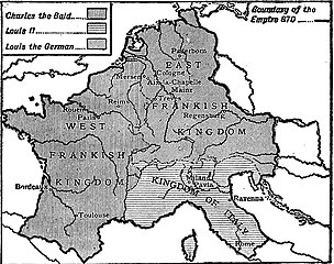
English: Map of Europe showing the Western Empire after the Partition of Mersen (also Meerssen) in 870. |
|||
| Date | published 1911 | |||
| Source | “Europe,” Encyclopædia Britannica (11th ed.), v. 9, 1911, p. 924 (right). | |||
| Author | Engraved by Emery Walker | |||
| Permission (Reusing this file) |
|

File history
Click on a date/time to view the file as it appeared at that time.
| Date/Time | Thumbnail | Dimensions | User | Comment | |
|---|---|---|---|---|---|
| current | 16:13, 10 August 2018 | | 873 × 690 (236 KB) | Library Guy (talk | contribs) | {{Information |description ={{en|1=Map of Europe showing the Western Empire after the Partition of Mersen (also Meerssen) in 870.}} |date =published 1911 |source =“Europe,” ''Encyclopædia Britannica'' (11th ed.), v. 9, 1911, p. 924 (right). |author =Engraved by Emery Walker |permission ={{PD-Britannica}} }} Category:Maps of the Carolingian Empire Category:Old maps showing history of Western Europe |
You cannot overwrite this file.
File usage on Commons
The following page uses this file:
File usage on other wikis
The following other wikis use this file:
- Usage on en.wikisource.org