File:EB VA 139-South Allen Road; Virginian Rwy Xing.jpg

Size of this preview: 800 × 600 pixels. Other resolutions: 320 × 240 pixels | 640 × 480 pixels | 1,024 × 768 pixels | 1,280 × 960 pixels | 2,560 × 1,920 pixels | 3,648 × 2,736 pixels.
Original file (3,648 × 2,736 pixels, file size: 2.09 MB, MIME type: image/jpeg)
Captions
Captions
Add a one-line explanation of what this file represents
Summary
edit
| Description |
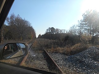
English: Eastbound along Virginia State Route 139 (South Allan Road) at the westernmost railroad crossing of the former Virginian Railway Main Line with in Jarratt, Greensville County, Virginia. Around the corner from here, VA 139 makes a sharp right turn at the intersection of Jarratt Avenue and cross this line again, albeit with slightly less overgrowth. In the meantime South Allen Road will become North Allan Road (Virginia Secondary Route 610). On the south side of this crossing is an unpaved portion of Gray Street (Virginia Secondary Route T-1107), and across VA 139 from there is the unusually wide right-of-way that seems too big for a Railroad Avenue and has no evidence of a freight siding. |
| Date | |
| Source | Own work |
| Author | DanTD |
Licensing
edit
I, the copyright holder of this work, hereby publish it under the following license:
This file is licensed under the Creative Commons Attribution-Share Alike 4.0 International license.
- You are free:
- to share – to copy, distribute and transmit the work
- to remix – to adapt the work
- Under the following conditions:
- attribution – You must give appropriate credit, provide a link to the license, and indicate if changes were made. You may do so in any reasonable manner, but not in any way that suggests the licensor endorses you or your use.
- share alike – If you remix, transform, or build upon the material, you must distribute your contributions under the same or compatible license as the original.
File history
Click on a date/time to view the file as it appeared at that time.
| Date/Time | Thumbnail | Dimensions | User | Comment | |
|---|---|---|---|---|---|
| current | 18:35, 9 January 2020 | | 3,648 × 2,736 (2.09 MB) | DanTD (talk | contribs) | User created page with UploadWizard |
You cannot overwrite this file.
File usage on Commons
There are no pages that use this file.