File:ECDM 20240326 TC GAMANE.pdf

Size of this JPG preview of this PDF file: 800 × 554 pixels. Other resolutions: 320 × 222 pixels | 640 × 443 pixels | 1,024 × 709 pixels | 1,280 × 886 pixels | 1,625 × 1,125 pixels.
Original file (1,625 × 1,125 pixels, file size: 517 KB, MIME type: application/pdf)
Captions
Captions
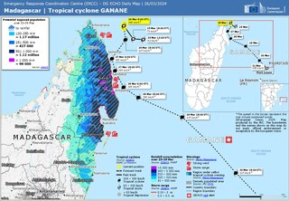
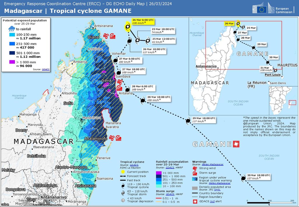
Madagascar | Tropical cyclone GAMANE
Summary
edit| Description |
Deutsch: Madagaskar: Mögliche Bahn (gestrichelte Linie) und Auswirkungen des tropischen Wirbelsturms GAMANE, veröffentlicht auf der ECHO-Tageskarte vom 26. März 2024. Dies ist kein Bericht, da der tatsächliche Weg von Gamane anders war.
English: Madagascar : Potential track (dashed line) and effects of Tropical cyclone GAMANE issued on the ECHO Daily Map of 26 March 2024. This is not a report as the real path of Gamane was different. |
| Date | |
| Source | https://erccportal.jrc.ec.europa.eu/ECHO-Products/Maps#/maps/4831 |
| Author | Emergency Response Coordination Centre; Sources: GDACS, Meteo Madagascar, JRC-GHSL |
Licensing
editPublic documents (any content whatever its medium) produced by the Commission or by entities on its behalf published by the Commission or the Publications Office or which have not been published for economic or other practical reasons, such as studies, reports and other data shall be made available for reuse unless otherwise specified[1] without restrictions according to 2011/833/EU: Commission Decision of 12 December 2011 on the reuse of Commission documents
Note: Content on ec.europa.eu or its data portal is published with the specified restrictions of the CC BY 4.0 license.
| |
File history
Click on a date/time to view the file as it appeared at that time.
| Date/Time | Thumbnail | Dimensions | User | Comment | |
|---|---|---|---|---|---|
| current | 20:39, 28 March 2024 |  | 1,625 × 1,125 (517 KB) | Lupe (talk | contribs) | Uploaded a work by Emergency Response Coordination Centre; Sources: GDACS, Meteo Madagascar, JRC-GHSL from https://erccportal.jrc.ec.europa.eu/ECHO-Products/Maps#/maps/4831 with UploadWizard |
You cannot overwrite this file.
File usage on Commons
The following page uses this file: