File:Earl 2010 track.png

Size of this preview: 740 × 599 pixels. Other resolutions: 296 × 240 pixels | 593 × 480 pixels | 948 × 768 pixels | 1,264 × 1,024 pixels | 2,529 × 2,048 pixels | 2,700 × 2,187 pixels.
Original file (2,700 × 2,187 pixels, file size: 1.65 MB, MIME type: image/png)
Captions
Captions
Add a one-line explanation of what this file represents
Summary
| Description |
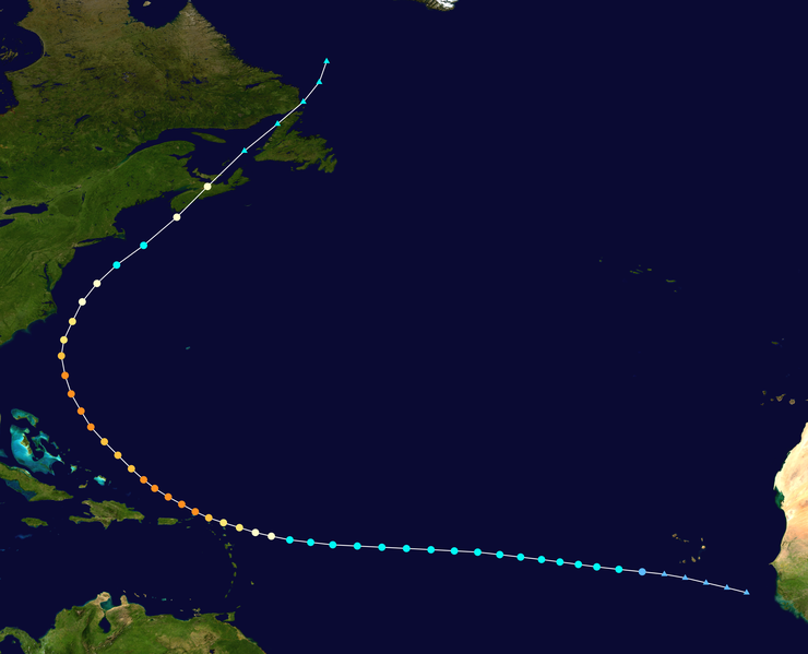
English: Track map of Hurricane Earl of the 2010 Atlantic hurricane season. The points show the location of the storm at 6-hour intervals. The colour represents the storm's maximum sustained wind speeds as classified in the (see below), and the shape of the data points represent the nature of the storm, according to the legend below. Tropical depression (≤38 mph, ≤62 km/h)
Tropical storm (39–73 mph, 63–118 km/h)
Category 1 (74–95 mph, 119–153 km/h)
Category 2 (96–110 mph, 154–177 km/h)
Category 3 (111–129 mph, 178–208 km/h)
Category 4 (130–156 mph, 209–251 km/h)
Category 5 (≥157 mph, ≥252 km/h)
Unknown
Storm type |
||
| Date | 2010-08-24–2010-09-06 | ||
| Source | Created by Anhamirak using Wikipedia:WikiProject Tropical cyclones/Tracks. The background image is from NASA. Tracking data is from the National Hurricane Center[1]. | ||
| Author | Anhamirak | ||
| Source code | Track map data table, if present below, is in HURDAT2 or ATCF format. See format details in [2] and [3], respectively.
|
Licensing edit
| This work has been released into the public domain by its author, Anhamirak. This applies worldwide. In some countries this may not be legally possible; if so: Anhamirak grants anyone the right to use this work for any purpose, without any conditions, unless such conditions are required by law. |
File history
Click on a date/time to view the file as it appeared at that time.
| Date/Time | Thumbnail | Dimensions | User | Comment | |
|---|---|---|---|---|---|
| current | 02:27, 28 July 2019 | | 2,700 × 2,187 (1.65 MB) | Supportstorm (talk | contribs) | 2700 px |
| 18:36, 18 January 2011 |  | 1,024 × 829 (325 KB) | Cyclonebiskit (talk | contribs) | TCR update | |
| 00:39, 12 November 2010 |  | 1,024 × 817 (306 KB) | Cyclonebiskit (talk | contribs) | updated | |
| 19:43, 5 September 2010 |  | 1,024 × 765 (355 KB) | Cyclonebiskit (talk | contribs) | final position from CHC; absorbed by another system | |
| 16:58, 5 September 2010 |  | 1,024 × 745 (345 KB) | Cyclonebiskit (talk | contribs) | ET points from Canadian Hurricane Centre | |
| 16:46, 5 September 2010 |  | 1,024 × 696 (316 KB) | Cyclonebiskit (talk | contribs) | update; final | |
| 14:08, 4 September 2010 |  | 1,024 × 633 (269 KB) | Cyclonebiskit (talk | contribs) | update | |
| 14:06, 3 September 2010 |  | 1,024 × 633 (276 KB) | Cyclonebiskit (talk | contribs) | updated; please remember to use --extra 1 when making the tracks please | |
| 04:09, 2 September 2010 |  | 1,024 × 633 (172 KB) | Syntheticalconnections (talk | contribs) | RBT has been updated. | |
| 00:21, 2 September 2010 |  | 1,024 × 633 (292 KB) | Cyclonebiskit (talk | contribs) | update |
You cannot overwrite this file.
File usage on Commons
The following 2 pages use this file:
File usage on other wikis
The following other wikis use this file:
- Usage on de.wikipedia.org
- Usage on en.wikipedia.org
- Usage on es.wikipedia.org
- Usage on fr.wikipedia.org
- Usage on ko.wikipedia.org
- Usage on nl.wikipedia.org
- Usage on pl.wikipedia.org
- Usage on pt.wikipedia.org
- Usage on ru.wikipedia.org
- Usage on simple.wikipedia.org
- Usage on www.wikidata.org
- Usage on zh.wikipedia.org