File:Early Toarcian Europe Map.png

Size of this preview: 741 × 600 pixels. Other resolutions: 297 × 240 pixels | 593 × 480 pixels | 850 × 688 pixels.
Original file (850 × 688 pixels, file size: 374 KB, MIME type: image/png)
Captions
Captions
Map of Early Toarcian Europe
Summary
edit
| Description |
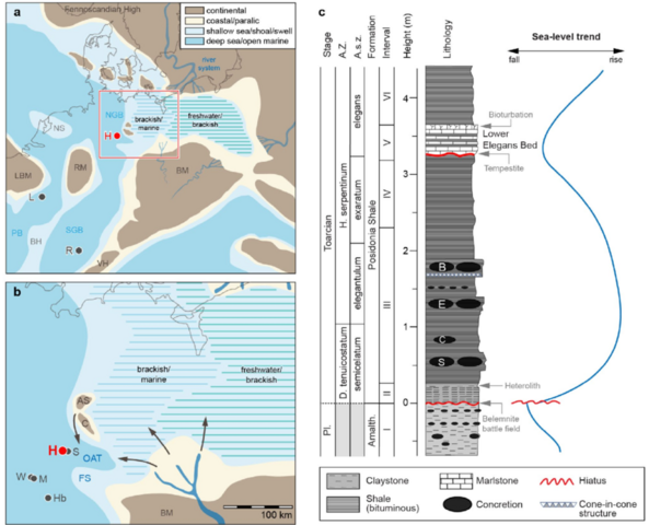
English: a: Palaeogeographic map of the Early Toarcian in northern Europe, showing the study site (H Hondelage) and localities mentioned in the text (R Rietheim and L Luxemburg) (BM Bohemian Massif, RM Rhenish Massif, LBM London Brabant Massif, VH Vindelician High, PB Paris Basin, SGB South-German Basin, NGB North-German Basin). The palaeogeographic map is modified from Ziegler (1990), Barth et al. (2018), and Ruebsam et al. (2020c, 2024). b: Detailed palaeogeographic reconstruction of the study area, the south-eastern North-German Basin. Localities mentioned in the text are: S: Schandelah, W: Wickensen, M: Mainzholzen, and Hb: Hainberg. Regional palaeogeographic elements, such as the Oberaller Trough (OAT), the Calvörde Island (C), the Altmark Swell (AS), and the Fallstein Swell (FS) are indicated. Sediment supply (arrows) was sourced from small islands in the north and from the Bohemian Mas-sif (BM) in the southeast (Zimmermann etal. 2018; Barth etal. 2018; Ruebsam et al. 2024; Ott 1967). c: Lithostratigraphic column with ammonite biostratigraphy (Mutterlose etal. 2022) and simplified sea-level trend (Hallam 1997; Morard etal. 2003; Wignall 2005; Rueb-sam and Al-Husseini 2021). A. Z.: Ammonite Zone; A. s.z.: Ammo-nite subzone; Interval I: Pliensbachian; Interval II: basal Posidonia Shale Formation; Interval III: T-CIE; Interval IV: post-CIE; Interval V: Lower Elegans Bed; Interval VI: upper Posidonia Shale Forma-tion. S: siemensi concretion layer; C: capillatum concretion layer; E: elegantulum concretion layer B: borealis concretion layer |
| Date | |
| Source | Marten, Tim (2024-06-27). "Latest Pliensbachian to Early Toarcian depositional environment and organo-facies evolution in the North-German Basin (Hondelage Section)". International Journal of Earth Sciences. DOI:10.1007/s00531-024-02433-7. ISSN 1437-3254. |
| Author | Tim Marten, Wolfgang Ruebsam, Lorenz Schwark, Jörg Mutterlose |
Licensing
edit
This file is licensed under the Creative Commons Attribution 4.0 International license.
- You are free:
- to share – to copy, distribute and transmit the work
- to remix – to adapt the work
- Under the following conditions:
- attribution – You must give appropriate credit, provide a link to the license, and indicate if changes were made. You may do so in any reasonable manner, but not in any way that suggests the licensor endorses you or your use.
File history
Click on a date/time to view the file as it appeared at that time.
| Date/Time | Thumbnail | Dimensions | User | Comment | |
|---|---|---|---|---|---|
| current | 23:08, 30 June 2024 | | 850 × 688 (374 KB) | Olmagon (talk | contribs) | Uploaded a work by Tim Marten, Wolfgang Ruebsam, Lorenz Schwark, Jörg Mutterlose from {{Cite journal |last=Marten |first=Tim |last2=Ruebsam |first2=Wolfgang |last3=Mutterlose |first3=Jörg |last4=Wiesenberg |first4=Guido L. B. |last5=Schwark |first5=Lorenz |date=2024-06-27 |title=Latest Pliensbachian to Early Toarcian depositional environment and organo-facies evolution in the North-German Basin (Hondelage Section) |url=https://www.researchgate.net/figure/a-Palaeogeographic-map-of-the-Early-To... |
You cannot overwrite this file.
File usage on Commons
There are no pages that use this file.
File usage on other wikis
The following other wikis use this file:
- Usage on en.wikipedia.org